Tips for Visiting Canyonlands National Park
Located in southeast Utah, you’ll enjoy views of red rock canyons and mesas carved by the Colorado River when visiting Canyonlands National Park.
Use this Canyonlands National Park guide to plan the most amazing vacation: services, weather, things to do, what to pack, and where to stay!
Canyonlands provides visitors with a fantastic assortment of outdoor activities like hiking, backpacking, river rafting, photography and camping.
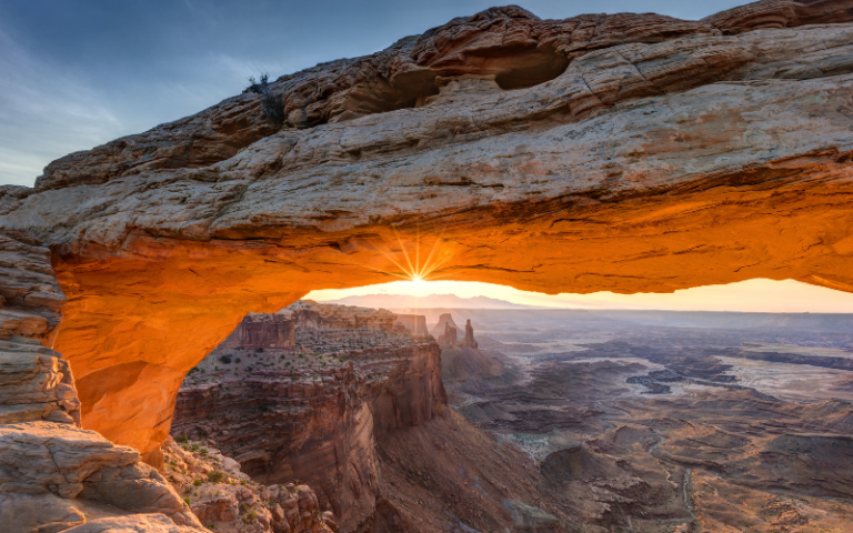
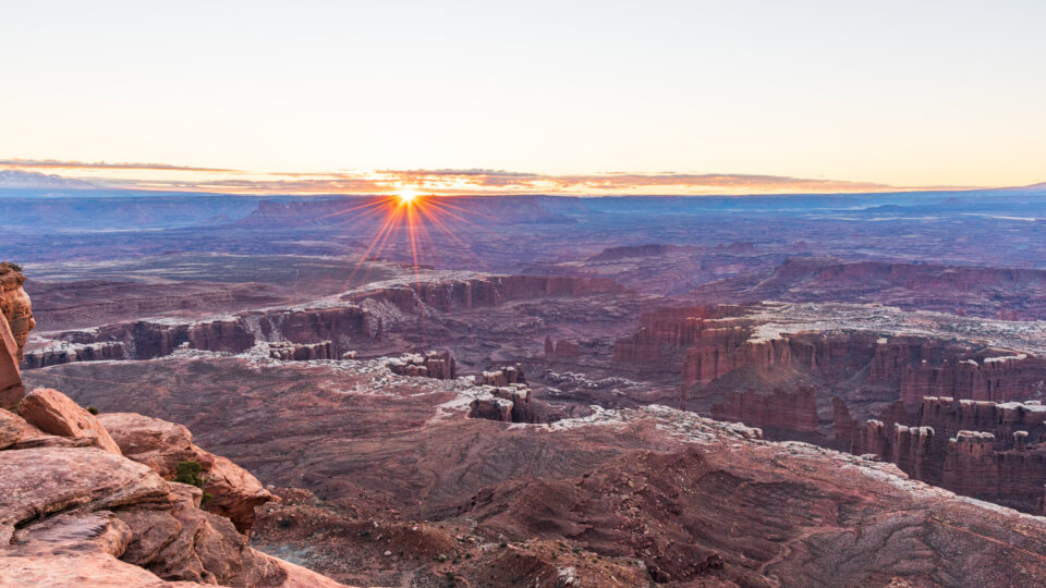
The park’s diverse geology provides a stunning backdrop for watching and photographing sunrise and sunset! Mesa Arch at sunrise is one of the most iconic locations at Canyonlands!
Check out these Canyonlands itineraries to help you plan your vacation based on the time you have to spend at the park:
- Canyonlands National Park One Day Itinerary
- Two Days at Canyonlands National Park
- Three Days at Canyonlands National Park
- One Day at Needles Canyonlands National Park

This site contains affiliate links which means WE may receive commissions for purchases made through these links. We only provide links to products we actually use and/or wholeheartedly recommend! As an Amazon Associate, we earn from qualifying purchases. Read the full Disclosure Policy.
A Photo Tour of Canyonlands National Park
Take a visual tour through Canyonlands National Park (and Dead Horse Point) to see the stunning landscape in the parks!
Visiting Canyonlands National Park: The Basics
Within this 337,598 acre park, visitors will find exquisite natural canyons, arches, fins, buttes, mesas, and spires that have all been carved out by the awe-inspiring power of the Green and Colorado Rivers.
Because of these two rivers and their natural flow pattern through the park, Canyonlands has been further subdivided into four unique districts.
Canyonlands Four Districts
Canyonlands is subdivided, along the Green and Colorado Rivers, into four unique districts: Canyonlands National Park Island in the Sky, Needles Canyonlands, The Maze, Island in the Sky, and The Rivers.
Of all the districts in Canyonlands National Park, we recommend visiting Island in the Sky because it’s the most accessible and offers fantastic, panoramic views of the park along the scenic drive.
Take a short side trip to visit Dead Horse Point State Park near the entrance to Island in the Sky. It is a must-see location!
In contrast, when you visit The Needles Canyonlands, you’ll experience a remote, backcountry experience with an assortment of natural geologic formations that can only be reached by using one of the many Canyonlands hiking trails or four-wheel driving trails.
Here’s a good article we wrote detailing Canyonlands Island in the Sky vs Needles!
Then there is The Maze, the most remote of all of the Canyonlands districts. That’s why a visit here requires a bit more time and self-reliance to explore all the fascinating natural formations in this area, like the Orange Cliffs. The nearby Horseshoe Canyon Unit, which sits just northwest of The Maze and is a common day-use area where guests can see a wide array of amazing, American Indian rock art panels.
Lastly, enjoy The Rivers with a calm, flat water trip on the Green or Colorado rivers or a more thrilling whitewater river rafting trip in Cataract Canyon. The river adventures are unique ways to experience Canyonlands and usually involve two or more days of boating.
When to Visit Canyonlands National Park
Canyonlands is located in Southeast Utah, part of the Colorado Plateau “high desert”. This area has large temperature fluctuations, sometimes up to 40 degrees in a single day!
The best time to visit Canyonlands National Park is during the most temperate seasons in the spring (April through May) and fall (mid-September through October). The spring and fall daytime highs average 60º to 80ºF and lows average 30º to 50ºF .
Summer temperatures often exceed 100ºF! Outdoor activities should be limited to the cooler morning and evenings. Late summer monsoon season brings violent storm cells which often cause flash floods that affect Needles Canyonlands.
Winters temperature highs average 30º to 50ºF and lows average 0º to 20ºF. So it’s cold! Large amounts of snow in the park are uncommon, but even small amounts of snow or ice can make the park trails and roads impassable. Be prepared with the right winter clothing and gear!
Winter is a wonderful time to visit, but you need to monitor the Canyonlands website for updated closures.
- Canyonlands National Park in the Spring
- Canyonlands National Park in the Summer
- Canyonlands National Park in the Fall
- Canyonlands National Park in the Winter
Canyonlands National Park Operating Hours
Canyonlands National Park is open 24 hours a day, 365 days a year, with some facilities, like many visitor centers and campgrounds, closing for the winter season. Check the Canyonlands National Park website for updated Visitor Center hours of operation.
Canyonlands National Park Fees
There are a variety of passes available to visit Canyonlands. Check the website for the most current fee prices and information.
BUDGET TRAVEL TIP: If you’ll be visiting nearby Arches National Park, or other Utah parks, we recommend getting the US National Park pass. (Did you know when you buy the National Parks Pass from REI, they donate 10% to the National Park Foundation?)
Canyonlands National Park Weather
Canyonlands National Park sits on the Colorado Plateau and is characterized as a “high desert” region. As such, this area experiences extreme temperature fluctuations, sometimes over 40 degrees, within a day.
When it comes to Canyonlands National Park weather, the most temperate seasons at the park are spring (April-May) and fall (mid-September-October), when highs are between 60 and 80 F and lows are between 30 to 50 F.
In contrast, summer temperatures routinely exceed 100 F, making strenuous hiking and backpacking incredibly difficult. Similarly, winters are extremely cold with highs between 30 and 50 F and lows between 0 and 20 F, making staying warm outdoors extremely challenging.
Canyonlands National Park Pets Policy
Pets are welcome to visit Canyonlands National Park and are permitted at the Willow Flat campgrounds in Island of the Sky, Squaw Flat campgrounds in The Needles, along paved scenic drives and parking lots, and on the Potash/Shafer Canyon Road between Moab and Island in the Sky.
In contrast, pets are not allowed at overlooks, along hiking trails, anywhere in the backcountry, on rivers, and on backcountry roads, even if riding in a vehicle.
Also, always remember that the desert can be a very dangerous place for pets since car temperatures can escalate quickly and result in heat exhaustion.
Canyonlands National Park Goods and Services
Because Canyonlands is a remote and rugged place, there is no lodging (except several campgrounds), food, or gas services available in the park. However, you can find a range of full services in several nearby towns, like Moab.
That being said, it’s always important to pack everything you’ll need for your visit to Canyonlands since water is only available at the Island in the Sky Visitor Center (except during the winter), and at The Needles Visitor Center.
The Island in the Sky and The Needles Visitor Centers do offer guests public, unsecured WIFI.
Extremely limited call phone service is also available within the Island in the Sky Visitor Center, at scenic drive locations where the La Sal Mountains are visible, along the east side of the White Rim Road, and along the Orange Cliffs Mesa where the La Sal Mountains are visible.
Canyonlands National Park Maps
Before you set out on your journey, it’s important to be prepared with detailed Canyonlands printable maps that will help guide you through each district of the park.
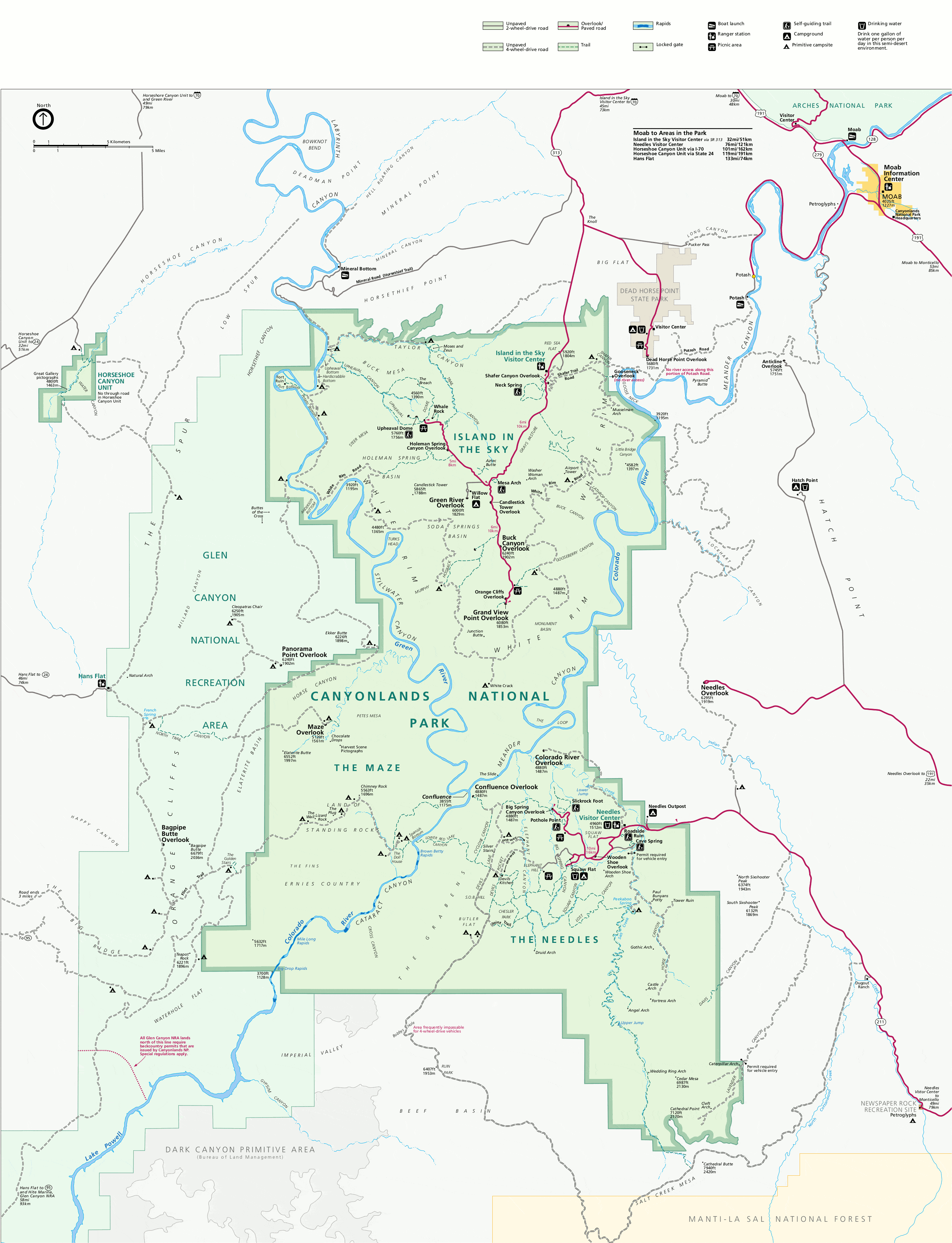
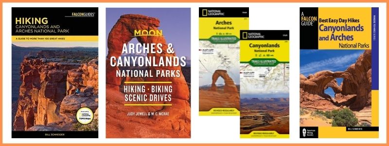
BUY AT AMAZON: Arches and Canyonlands Guides and Maps
Getting to Canyonlands
From Grand Junction, Colorado, take I-70 west and follow the highway until Thompson Springs. Take exit 182 and follow US-191 south towards Moab. Continue along US-191 until you reach UT-313 and turn right. It should take an hour and 53 minutes and cover 121 miles.
From Salt Lake City, Utah, take I-15 south until exit 257 B-A for US-6 East. Continue on US-6 East and merge onto I-70 East. Take exit 182 onto US-191 south towards Moab. Continue along US-191 until you reach UT-313 and turn right. It should take under 4 hours to drive 242 miles.
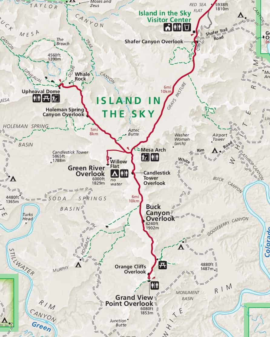
Points of Interest at Canyonlands Island in the Sky
The Island in the Sky is the easiest district to visit in a short amount of time since there are a ton of pull outs here that sit along a well paved, scenic drive that offers visitors spectacular views of sheer, sandstone cliffs that give this region its unique landscape.
We recommend the Canyonlands GuideAlong App to hear fun behind-the scenes stories and local tips that play automatically as you drive, based on your GPS location. It’s like having a park ranger in the car with you!
You’ll also find many easy, moderate, and strenuous Island in the Sky hikes, four-wheel-drive road, and backcountry trails to explore the area’s breathtaking landscape.
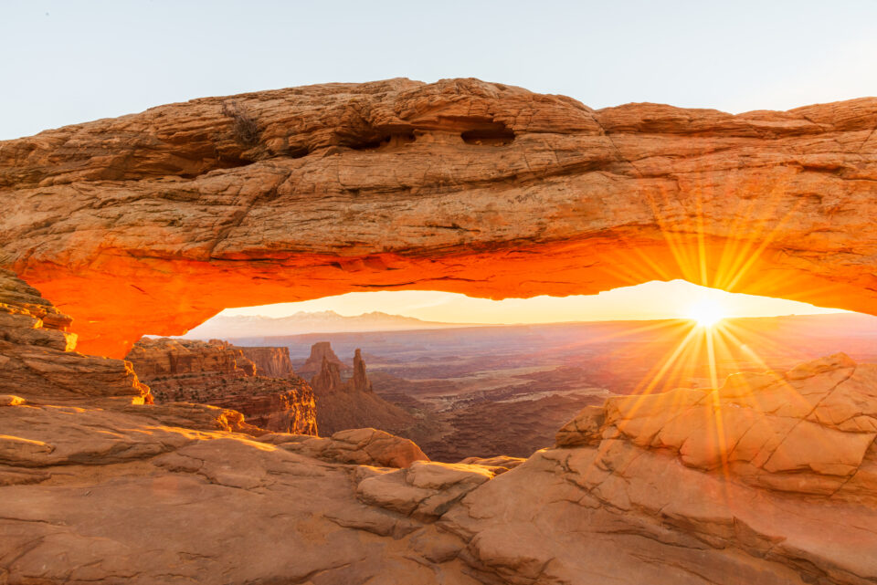
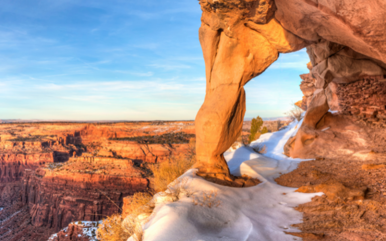
Mesa Arch
A popular and easy, 30-minute hike along the loop Mesa Arch Trail, to a magnificent natural arch near the edge of a sheer cliff face. You’ll also be able to spot the famous Washer Woman here, through the crest of the arch.
Grand View Point
This stop at the end of the Island in the Sky scenic drive offers a fantastic place to see the majestic White Rim as well as The Maze, and The Needles. A short, 300 foot, paved sidewalk also leads to a spectacular viewpoint. Just beyond this paved platform, you can find a trail that will lead you down a stone staircase and towards a second viewpoint that is just 2 miles away.
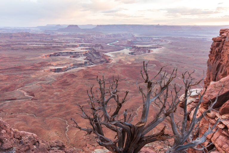
Green River Overlook
From here, visitors can enjoy breathtaking views of the surrounding canyonlands and the majestic Green River, a view that extends out for hundreds of miles in every direction.
Buck Canyon Overlook
A wheelchair accessible overlook that offers incredible views of enormous, 1,000 foot tall, sheer cliffs that form the mesa. From here, you can also see the cracked sandstone along the bottom of the canyon, the iconic Washer Woman rock formation, and even the La Salle mountains.

Aztec Butte
A fun but steep and challenging 2 mile long hike that takes roughly 1.5 hours to complete and culminates in expensive views of the surrounding area.
White Rim Road
A 100-mile long, dirt road that sits at the bottom of the canyon and runs around the Island in the Sky mesa top. Those with a high clearance/4WD vehicle can also drive along the Shafer Trail to the White Rim Road and visit Musselman Arch and the Colorado River Gooseneck.
Murphy Point Trail
An easy, 3.6 mile Canyonlands hike that takes two hours to complete and leads guests past historic corrals, and culminates in fantastic, panoramic views of the surrounding area.
Upheaval Dome
A moderately difficult hike with two different viewpoints for you to explore. The first viewpoint is a 1 mile away from the trailhead and takes only 30 minutes to get to. The second viewpoint adds another mile to your hike and takes you past some of the area’s most beautiful natural landscapes in the area.
Whale Rock
An intermediate level, 1-mile long hike that takes about an hour to complete. At the end of the trail, you’ll find stunning views of Upheaval Dome and the surrounding area.
Neck Spring
This strenuous, 5.8 mile loop trail can take between 3 and 4 hours to complete and takes you past some historic ranching features and two lovely seep springs.
Gooseberry Canyon
A difficult, 5.4 mile long trail that begins at White Rim Overlook and leads you out into Gooseberry Canyon.
Syncline Loop
A challenging, 8.3 mile hike that takes you through the many canyons surrounding Upheaval Dome.
Murphy Loop
A 10.8 mile long trail that takes between 5 and 7 hours to complete. Along the Murphy Loop, hikers descend into a canyon, cross hogback along White Rim Road, and then return via a rocky wash.
Alcove Spring
This 11.2 mile Canyonlands hike takes between 6 and 7 hours to complete and takes visitors past a large alcove and through a wide canyon where guests can enjoy the beauty of Moses and Zeus Towers.
Wilhite Canyon
A 12.2 mile long trail where you descend along steep switchbacks, into a rocky wash, and then return along a 1,600 foot elevation change.
Lathrop Canyon
An arduous, overnight hike that is 21.6 miles long and descends from the Mesa top, into the Colorado River, and back, along rocky washes and a 4WD road.
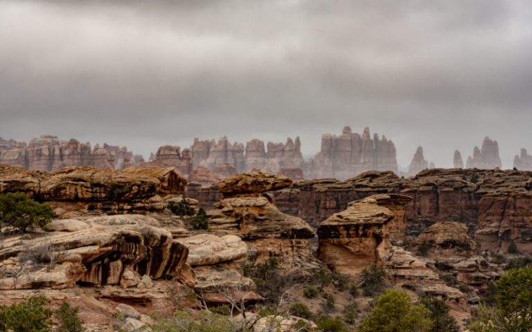
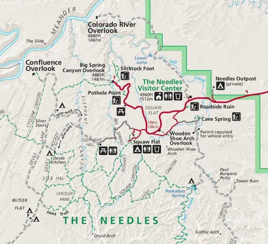
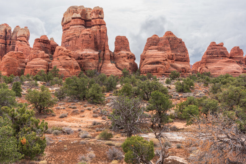
The Needles Canyonlands Points of Interest
This section of Canyonlands National Park is 40 miles south of Moab. You’ll find adventurous things to do at Needles Canyonlands to explore the natural landscape filled with brilliantly colored spires of Cedar Mesa sandstone.
Enjoy a variety of easy, moderate, or strenuous Canyonlands Needles hikes, backpacking, biking, and camping!
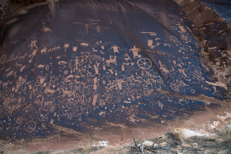
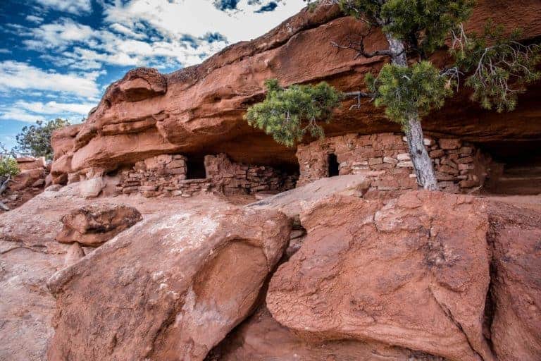
Newspaper Rock
Technically, Newspaper Rock isn’t part of Canyonlands National Park but is actually a Utah State Historic Monument that you pass while driving to The Needles. However, a stop here is must so that you can see amazing rock panels filled with petroglyphs that are almost 2,000 years old!
Roadside Ruin
An easy, 0.25 mile long loop trail that takes 45 minutes to complete. Along the way you’ll see an 800 year old, Puebloan-era granary that is tucked beneath a charming rock overhang.
Cave Spring Trail
A quick and easy, loop trail that takes between 30 and 90 minutes to complete. You’ll also find an abandoned cowboy camp and ancient pictographs along the way.
Elephant Hill Road
Drive along Elephant Hill Road to get a good view of the needles formations from the top of the hill.
Pothole Point Trail
Pothole Point trail is a short, 0.6 mile loop that takes anywhere between 30 and 60 minutes to complete and culminates in fantastic views of the many Needles formations in the area.
Slickrock Trail
This 2.4 mile trail takes 2 hours to complete, takes you across uneven surfaces, and gives you fantastic panoramic views of the area.
Big Spring to Squaw Canyon
This 7.5 mile trail takes between 3 and 4 hours to complete, and offers guests 2 backpacking sites that both offer water availability seasonally.
Squaw Canyon to Lost Canyon
This 8.6 mile trail takes between 4 and 6 hours to complete, leads you deep within the canyon, and has 3 backpacking sites with seasonal water availability.
Confluence Overlook
A 10 mile trail that takes between 5 and 6 hours to complete, and leads to a beautiful cliff that overlooks the joining of the Green and Colorado Rivers.
Peekaboo
This 10 mile trail that takes between 5 and 6 hours to complete, and has two ladders that must be climbed. One 4 wheel drive campsite is at the end of the trail and has seasonal water availability.
Chester Park/Joint Trail
An 11 mile long trail that takes between 5 and 7 hours to complete. This hike also has 5 backpacking sites (no water) along the way, and culminates in exquisite views of the surrounding desert grasses and colorful sandstone spires.
Druid Arch
A difficult, 11 mile trail that takes between 5 and 7 hours to complete.This Canyonlands hike also has 3 backpacking sites along the way with water available seasonally.
Lower Red Lake Canyon
A multi-day, 18.8 mile long trail that involves a strenuous hike in and out of the Grabens, as well as a steep descent into the river.
Salt Creek Canyon
A multi-day, 22.5 mile hike that begins at Cathedral Butte and then cosely follows the river drainage. Along the way, you’ll see many arches and archeological sites, in addition to 4 designated campsites in the upper section.
The Maze District Points of Interest
The Maze district of Canyonlands is the least accessible due to its remote location and the difficulty of roads and trails there.
You must be prepared for self-sufficiency and the proper equipment or gear for self-rescue.
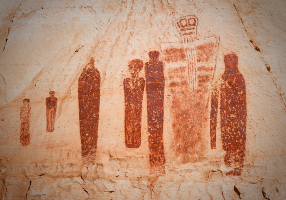
Horseshoe Canyon
One of the most popular hiking trails in The Maze, Horseshoe Canyon is known for having some of the most significant pieces of rock art in all of North America.
However, along this popular Canyonlands hiking trail, you’ll find a fantastic assortment of wildflowers, sheer sandstone walls, and cottonwood groves that sit along the stream at the bottom of the canyon.
The trail to The Great Gallery is 7 miles long and will take approximately 5 hours (or more) to complete. As you continue your hike, be prepared for uneven terrain, deep rocky areas, and thick sand, Also, make sure to pack your own water (1 gallon per person) and remember that pets are not allowed on this trail.
The only camping in the area can be done at the West Rim trailhead, where there is a vault toilet but no running water.
Because The Maze is so remote, all other trails are overnight, backpacking trails that require a permit and include:
The Maze Overlook Trail
This route through The Maze requires basic climbing maneuvers to navigate sections of steep slickrock and pour-offs. The aid of a rope is often essential for raising or lowering packs in difficult spots. Therefore, this trail is not advised for anyone with a fear of heights.
Visitors with two-wheel-drive vehicles can park at the North Point Road junction, and hike 15 miles to the Maze Overlook. Depending on the vehicle, hikers may also be able to drive the 14-mile road to park at the top of the Flint Trail switchbacks.
Things To Do at Canyonlands National Park
You’ll find a wide variety of Canyonlands National Park activities you can enjoy year-round:
Canyonlands Ranger Led Programs
If you want to learn more about the natural and cultural resources at the park, we recommend you join a Canyonlands ranger-led program: Ranger talk, Ranger hike, or evening program. Schedules and times vary, so please check locally at visitor centers and campground bulletin boards for current listings.
Island in the Sky: rangers conduct daily programs throughout the spring and fall, which include talks at the visitor center as well as trips to nearby overlooks. The stargazing program is also available, but rotates with Arches and Dead Horse Point.
The Needles: evening stargazing programs are offered most nights throughout the spring and fall.
The Maze: Ranger led guided walks are conducted through Horseshoe Canyon during the spring and fall. These guided walks are strenuous, 7 mile hikes that take anywhere between 4 and 6 hours to complete. Therefore, participants need to pack a lunch, a gallon of water per person, and any other necessary hiking essentials.
Photography at Canyonlands
Canyonlands National Park photography is all about capturing the stunning landscape scenes at both parks. The main subject of the photos here is the rock formations and vast canyons seen from the overlooks.
“The use of unmanned aircraft (DRONES) is prohibited to protect public safety, minimize visitor-use conflicts, and prevent unacceptable impacts to scenic values, natural soundscapes, and wildlife.”
Some of our favorite photo spots at Canyonlands Island in the Sky:
- Mesa Arch at sunrise
- Grand View Point at sunrise
- Green River Overlook at sunset
- Buck Canyon Overlook late afternoon
- Aztec Butte ruins
Our favorite photo spots at Needles Canyonlands:
- Newspaper Rock
- Needles spires along Elephant Hill Road
- Needles spires in Chesler Park
- Druid Arch
- Colorado River Overlook
CHECK OUT our Arches and Canyonlands Photography Guide that details the best photo spots during the best light!
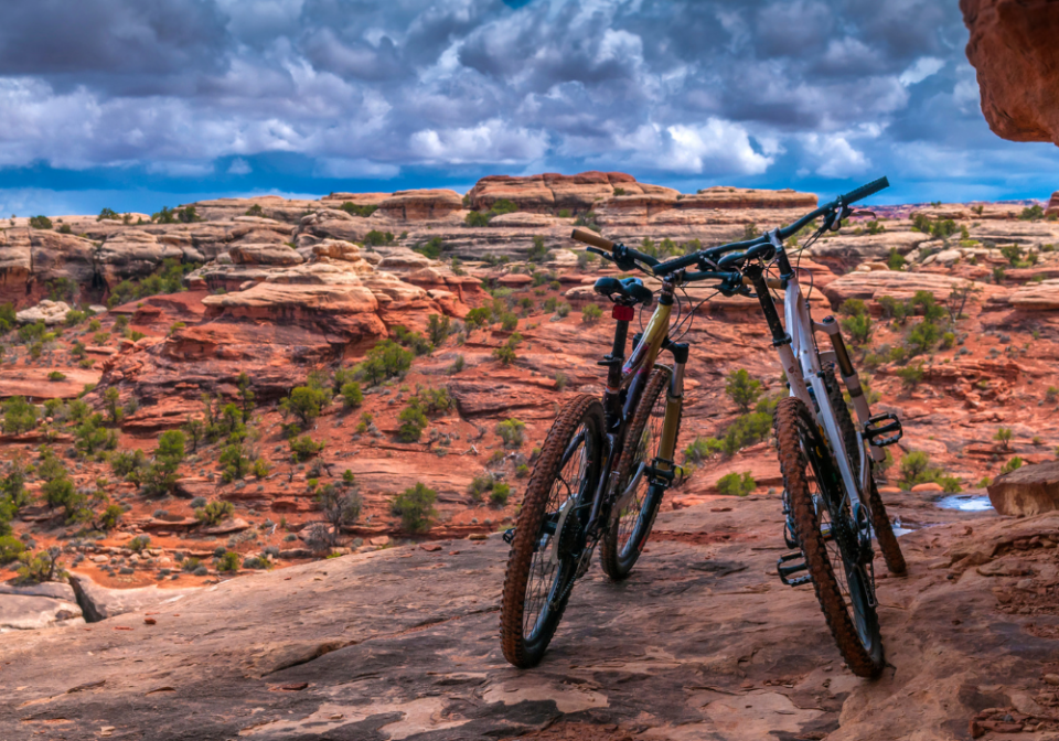
Biking at Canyonlands
With hundreds of miles of trails to be explored, mountain biking at Canyonlnads has become a popular activity over the years.
Bikers must remember to stay on designated roads at all times. Additionally, groups must camp in only designated sites (with a valid overnight permit), and bikers must always be aware of passing vehicles since there are no shoulders or bike lanes.
Riders must also have a day-use permit for trips along White Rim, Elephant Hill, Lavender Canyon, and Peekaboo/Horse Canyon. However, be aware of the fact that White Rim permits are incredibly popular. Therefore, a permit reservation should be made well in advance (you can reserve a White Rim permit up to 4 months in advance. Biking at Canyonlands is a popular activity.
White Rim Road – This Island in the Sky trail loops around and beneath the Island in the Sky mesa top and provides amazing panoramic views of the surrounding landscape. Bicycle trips usually take between three and four days, with overnight and day-use permits are required.
Elephant Hill Road – This trail through The Needles is one of the most technical roads in Utah. Day-use and overnight permits are required and no water is available along the trail.
Colorado Overlook Trail – This road through The Needles is moderately difficult and can be a bit sandy for mountain bikes.
The Maze has bike terrain that is similar to, but a bit more technical than White Rim Road.
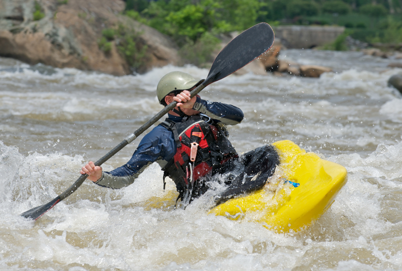
River Rafting and Kayaking at Canyonlands
The Colorado and Green Rivers dominate the landscape of Canyonlands National Park. Accordingly, seeing Canyonlands from one of these majestic rivers gives guests a unique perspective that is not to be missed.
Before any Canyonlands river rafting trip you must obtain a permit as they are required for all private, overnight trips and can be reserved no more than 4 months and no less than 2 days before your trip (you may need an additional permit for packrafting).
Head above the confluence of these two rivers and you will find calm, flat water that is perfect for canoeing and kayaking. Venture below the confluence and you’ll find a 14-mile stretch of III to V class rapids that are perfect for white water rafting.
You can also join a guided, white water rafting trip with a local company, many of whom provide visitors with an assortment of guided trips that range in length from a half day to several nights of camping.
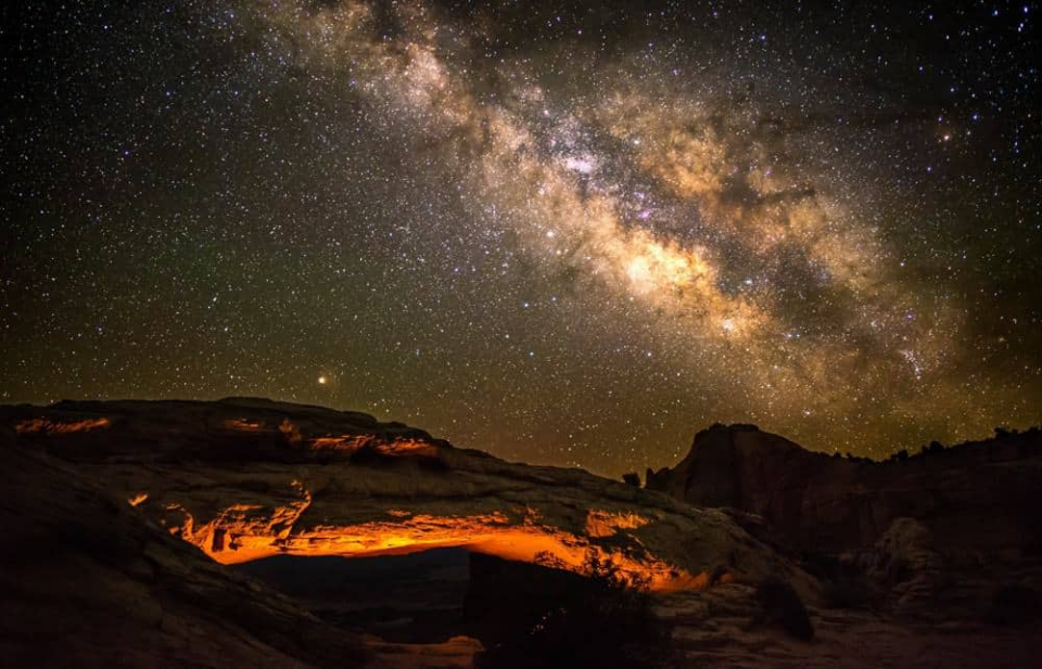
Stargazing at Canyonlands
Throughout the spring, summer, and fall, a ranger-led stargazing program is conducted, around sunset, at Island in the Sky (programs rotate with Arches national Park and Dead Horse Point State Park). The program introduces visitors to the beauty of the night sky through stargazing and telescope viewing.
Visitors are encouraged to bring a chair or a blanket to sit on, as well as a headlamp with a red light or red flashlight (if you have one), and warm clothes.
Stargazing events at The Needles begin at the Visitors Center and include a night sky program, followed by telescope viewing.
In contrast, stargazing events at The Maze are occasional, throughout the spring and fall, and take place in either good weather or bad.
BUY AT AMAZON: Arches and Canyonlands Guides and Maps
Where to Stay Near Canyonlands
There are no lodging facilities in the park, but there are campgrounds:
- Island in the Sky Campgrounds
- Needles Canyonlands Camping
- Where to Stay Near Canyonlands
- Hotels Near Canyonlands National Park
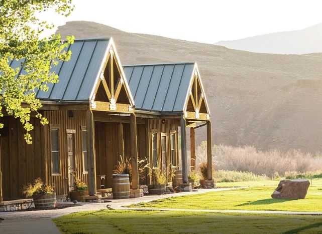
- Holiday Inn Express Hotel & Suites Moab – we enjoyed our stay and highly recommend this hotel due to its location close to Canyonlands.
- Purple Sage – our all-time favorite place to stay in Moab – walking distance to shopping, full kitchen, and only 8 units so you don’t feel lost in a large hotel.
- Red Cliffs Lodge – rooms up to 6 people – located 17 miles from Moab, this lodge is known for its beautiful location, winery and activities like horseback riding, fishing and more!
- Townhomes south of Moab – we really like the townhomes in Spanish Valley with kitchen, washer and dryer in the unit and a swimming pool/hot tub (just a 5 minute drive south of Moab).
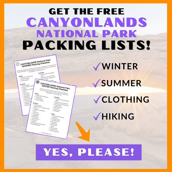
Canyonlands Packing List
Use our Canyonlands Packing List to make sure you have the right clothing and gear for visiting any time of year! Grab your free printable packing checklist by clicking the image below!