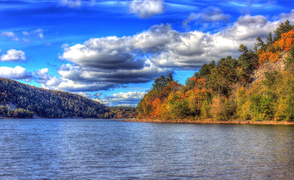
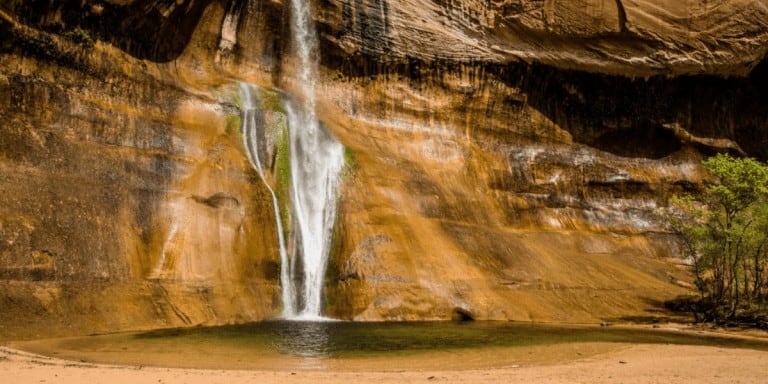
Best Summer Hiking Trails in the US
If you’re looking for US travel ideas to explore the diverse landscape of the US, take a look at this list of best summer hiking trails.
You’ll find awesome hikes in the US National Parks, State Parks and Forest Service land. There are easy, moderate or strenuous hiking trails to explore the outdoors.
The United States is home to thousands of miles of trails, from rugged mountain peaks and tranquil forests to rolling hills and sweeping desert landscapes. With so many options, it can be hard to decide which hiking trail is best for your summer vacation.

Summer is the most popular time for people to enjoy the outdoors which means trailheads and hiking trails will be busy. The best tip for summer hiking: GO EARLY! You’ll avoid the crowds and heat of the day.
We have teamed with other hikers to provide this list of US summer hikes. So grab your gear and get ready – the great outdoors awaits!

This site contains affiliate links which means WE may receive commissions for purchases made through these links. We only provide links to products we actually use and/or wholeheartedly recommend! As an Amazon Associate, we earn from qualifying purchases. Read the full Disclosure Policy.
Summer Hiking Gear
- Hiking shoes
- Darn Tough socks
- Wicking, quick-drying clothing: UV shirts, pants or shorts
- Bandana, buff headband or brimmed sun hat
- WATER – water bottles or hydration backpack
- Healthy snacks
- Flashlight or headlamp
- National Park maps
- Sunscreen
- Lip protection with sunscreen
- Polarized sunglasses
- What to Bring on a Day Hike
- Hiking Gear and Tips for Kids
- Photography Gear for Hiking
- Best Cameras for Hiking

US National Park, State Park, and Forest Service Hiking Trails
Hiking is one of the best ways to experience and appreciate the outdoors. The summer hikes at US National Parks, state parks or forests take you over mountain peaks, through tall forests, across desert slickrock and even IN rivers.
The US National Park website, the local state park website and US Forest Service website have terrific information about hiking in the parks, types of trails you’ll find in the parks and best tips for staying safe.
Always check the individual park website, or Forest Service trail site, for current updates on trail conditions.
Do your research before starting any hiking trail, even the easy ones. Visit the website for the location you want to hike. You need to know about rock cairns, guidelines for archaeological sites, hiking etiquette, identifying plants, hiking in bear country, and more!
Best Summer Hiking Trails in the US
Thank you to the many hikers who have shared their knowledge about their favorite summer hike in the US! The list of hiking trails is in alphabetical order by state.
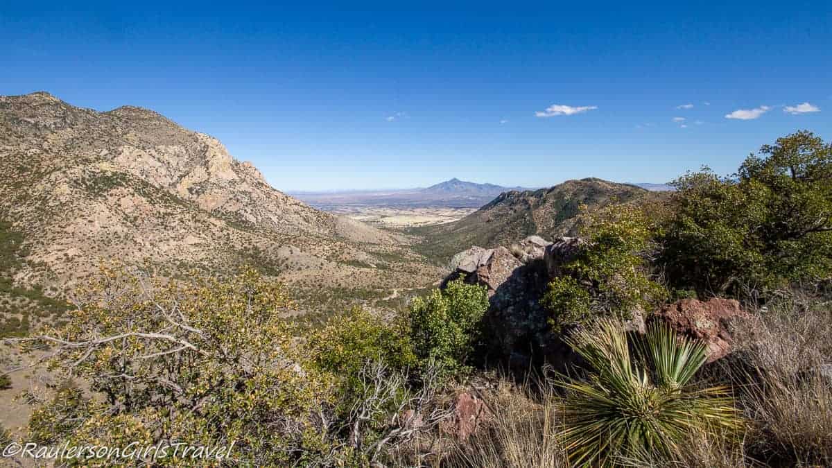
ARIZONA: Coronado Peak Trail
If you are driving through Arizona looking for some breathtaking views of the U.S. and Mexico, look no further than the top of Coronado Peak in Arizona.
The Coronado Peak Trail is a 0.8-mile round trip hike from the Montezuma Pass Overlook in the Coronado National Memorial. You might think that this is too short of a hike, but in a half-mile, you rapidly go up 250 feet in elevation.
Along the trail, there are interactive signs educating you about the Coronado Expedition, the native people they traded with and the plant life in the area. At one of the signs, it helps you figure out how long it took Coronado’s men to move a certain distance. And if you encounter other people on the trail, you might hear them counting out loud how many footsteps they are taking.
You might also see animal tracks on the trail such as deer or other wildlife that roam in the park. When you reach the summit, there are benches and a gazebo for you to stop and breathe in the beauty and the 360° views that are laid before you. This is a great trail to hike early in the day in the summertime. Article and photo: Raulerson Girls Travel
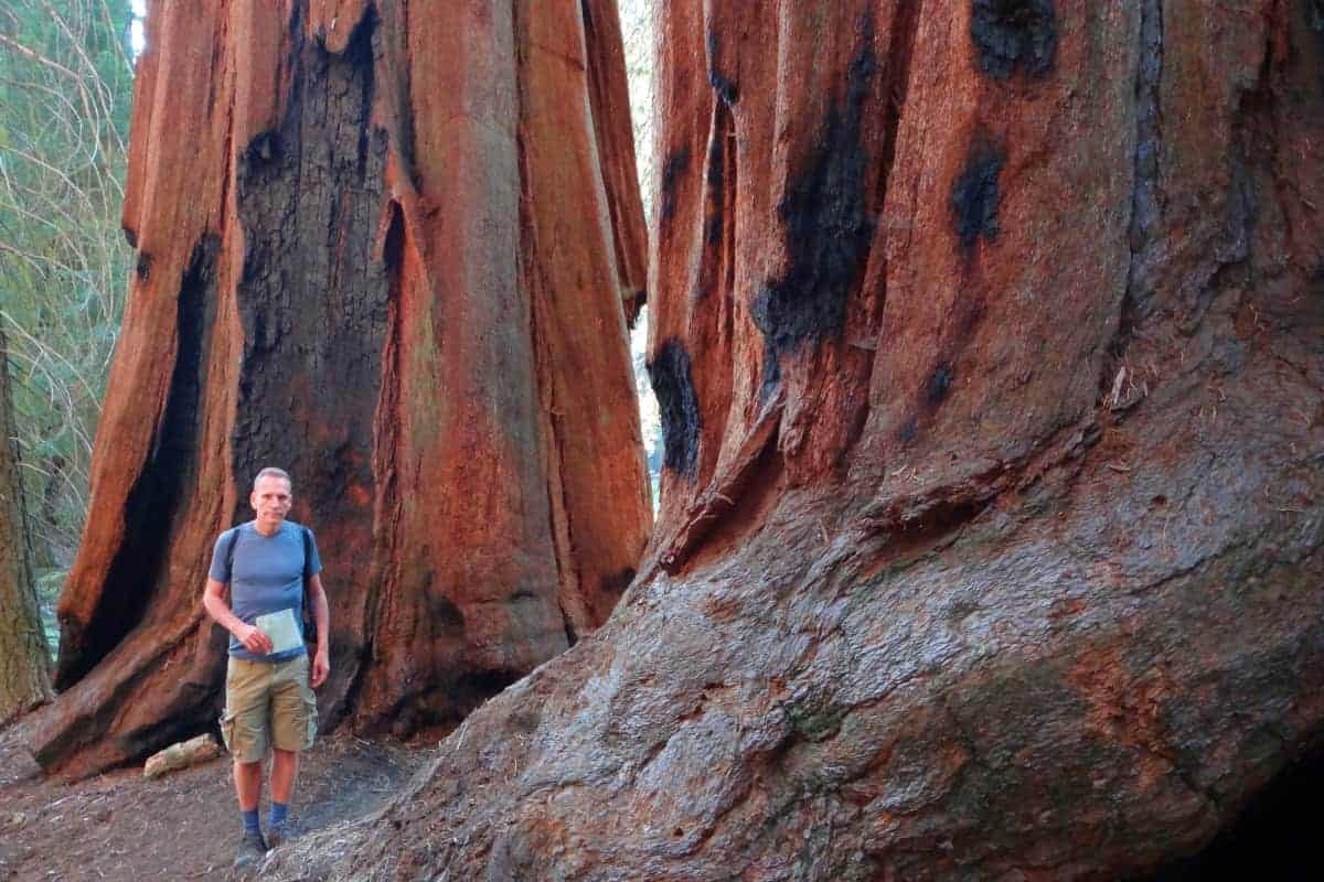
CALIFORNIA: Congress Hiking Trail, Sequoia National Park
One of the best summer trails is in Sequoia National Park. The park is home to the sequoia trees, which are the largest trees on earth. The trees grow in the mountains, so the park is often snowed in during the winter.
Summer, on the other hand, is perfect, as the air is cool and the trees provide shade to shelter you from the heat of the season.
The best trail in the park is the Congress Trail. The biggest sequoia trees are scattered along this trail. They have been given names such as President Tree, Chief Sequoya Tree, and Lincoln Tree. Two small groves of sequoias are called the Senate and the House. All of this helps the name of the trail make sense!
The two-mile loop trail starts at the General Sherman Tree (the largest tree on the planet), which itself is accessed along a half-mile trail from the parking lot. The Congress Trail then winds along a smooth and easy path through some pine trees and then past the Sequoias. There is even one tree (the aptly named Room Tree) that is hollow inside, with the empty space as big as a room. Yes, you can go inside. Occasionally a fallen giant lies across the path (a tunnel is carved in it, so you can walk through the trunk and continue along the trail), or deep into the forest. This helps give a sense of the sheer enormity of these incredible plants.
This is an easy trail, but one that will fill you with awe! Article and photo: Parks Collecting
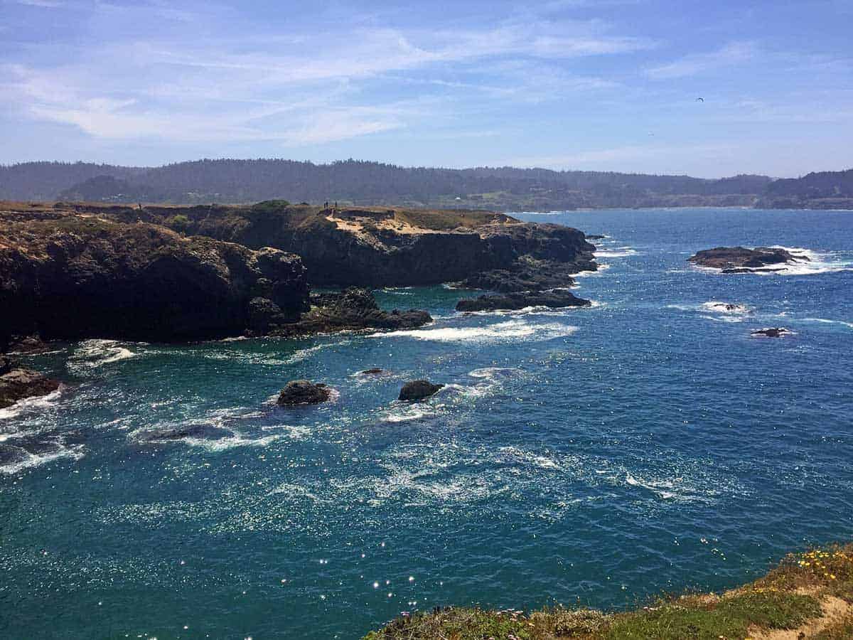
CALIFORNIA: Mendocino Headlands State Park Hiking Trails
Located along the cliffs of the northern California coast, Mendocino Headlands State Park offers beautiful trails traversing the cliff sides. Mendocino Headlands State Park is located in the sleepy coastal city of Mendocino.
The best hike at Mendocino Headlands State Park is the Mendocino Headlands Bluff Trail that takes you around much of the coastal area surrounding the city and the quaint downtown area. Plus, you’ll also get to see the islands just off of the coast! We’d recommend trying to do the trail in a loop so you’ll get a chance to explore downtown Mendocino at the same time.
Mendocino is a great place to visit during the summer months when the weather is warm. If you’re lucky you may even catch a sunny day where you can see the beauty of the area. To get there, take the Pacific Coast Highway north and road trip from San Francisco to Mendocino, then further north to the redwoods. Article and photo: The Adventures of Panda Bear
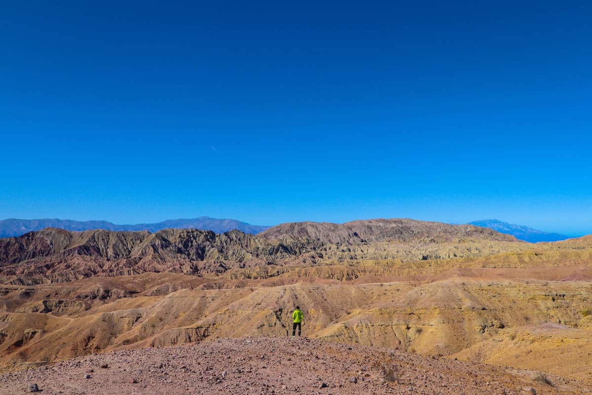
CALIFORNIA: Painted Canyon Hiking Trail
The Painted Canyons is a beautiful desert region near Palm Springs that we explored on our California road trip. Believe me, it’s called “painted” for a reason. The mountains there have colorful geological layers which were formed thousands of year ago and they make you feel like you are in one huge painting!
Hiking the Painted Canyon trail in the summer is one of the best times to enjoy the panoramic landscapes because the view will be clear. To avoid the heat of the day, hike early morning or evening. Or enjoy a unique clear sky full of stars by taking the trail at night!
The trail path is about 7 kilometers long and is considered a moderate hike. You’ll walk mainly on sand, but you’ll also hike between narrow breath-taking canyons and gain 300 meters of eleveation to reach the mountain top. You are rewarded with views of the stunning painted canyons.
The trail adds a bit more fun with ladders in the canyons that make climbing easier. So be careful! The trail is circular, but I recommend you to do it clockwise because it will be easier climbing up the ladders instead of climbing down them. Article and photo: Walk Beside Me Blog

COLORADO: Garden of the Gods Hiking Trails
Colorado Springs is a haven for nature lovers, making it one of the best places to visit for hikers. The amazing scenic views are unmatched, with one of the most beautiful being the Garden of the Gods. The park is famous for the red rocks that were formed from surface erosion, millions of years ago.
The Garden of the Gods is the perfect hiking destination for families with younger kids. The trails are paved to make it easier for your little one to walk or for you to use a stroller. If you are hiking with older kids there are 15 trails to choose from.
The summer is one of the best times to hike here because the weather is very tolerable, and you can enjoy the wildlife and vegetation. During the summer there are shuttles available in the parking lot every 15 minutes. This is helpful after hiking for several hours. If you are looking for the perfect views and truly immerse yourself in nature the Garden of the Gods is the perfect place. Article and photo: It’s a Family Thing

HAWAII: Koko Head Crater Trail
The Koko Crater Trail – otherwise known as Koko Head – follows an old railway track up the Koko Head mountain. There are a total of 1,048 steps from the bottom to the top of the ridge, so this hike isn’t for the faint-hearted! That being said, there is plenty of room to stop along the way and take in the amazing view, so you can take your time getting to the top. It usually takes anywhere from 30 minutes to an hour to get to the top.
Located on Oahu, not far from Waikiki Beach and overlooking the amazing Hanauma Bay, this hike is easy to get to from the Koko Head District parking lot, and there is also a bus stop nearby. You can even do a full guided tour, with hotel pickup and dropoff. This is a good option if you want to learn some more about the history of the mountain and surrounding area.
Though not a long hike, the ascent is incredibly steep and the ‘stairs’ (the wooden railway tracks) are quite high, so it will test even the fittest hikers! The track can become slippery in places, so it is best to go on a dry day in the Summer, as rain can make it really difficult. The hike can get quite busy, especially on weekends, so starting early morning is best – beat the crowds, and beat the sun. Many people also go in the late afternoon and catch the sunset, but bear in mind it can be very tricky finding your way back down in the dark!
Once you’re at the top, take a moment to congratulate yourself, catch your breath and admire the amazing views – make sure you bring your camera (or smartphone, these days)! You can even continue up the trail towards the metal platform, see some of the military pillboxes, or visit the Koko Crater Botanical Garden.
Be careful going back down, as it can be hard on the knees and slippery in places. Make sure you take water, and wear good sturdy shoes (even though people have been known to hike it in flip-flops). Sunscreen and a hat are also a must, especially in Summer – there is minimal shade along the route, but there are trees at the top of the trail that provide shade. Once you’re finished, you can pop across to nearby Hanauma Bay for a cool down and a snorkel!
If you’re into hiking, this iconic trail is a must-do when visiting Oahu. It is a challenge, but is relatively quick, views are to die for and best of all – it’s free! Article and photo: I Know the Pilot
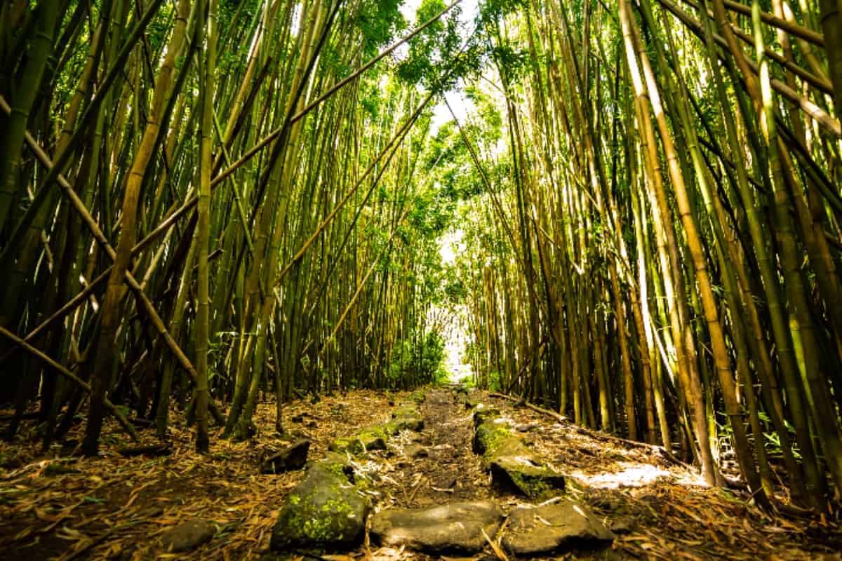
HAWAII: Pipiwai Trail, Haleakala National Park
When I think of summer, I think of hiking, camping, smores, bon fires, starry nights, and warm weather. Hawaii is no exception and although it feels like summer all year round hiking the Pipiwai Trail on Maui is a highlight of anyone’s summer.
The Pipiwai Trail can be found in the Kipahulu district of Haleakala National Park. This moderate 4 mile round trip hike gets better every step you take. The first mile takes you by several overlooks where you can spot waterfalls in the distance and past a very photogenic banyan tree.
The second mile begins as you enter an enchanting bamboo forest. You’ll hear whispers of the bamboo crack in the breeze as you make your way along the raised platform. The towering bamboo provide perfect shade to protect you from the summer sun.
If the bamboo forest wasn’t enough the hike ends at the awe inspiring 400 foot waterfall known as Waimoku Falls. Make sure you bring a snack to enjoy on the rocks near the base of the waterfall as you take in her beauty. Article and photo: I’m Jess Traveling
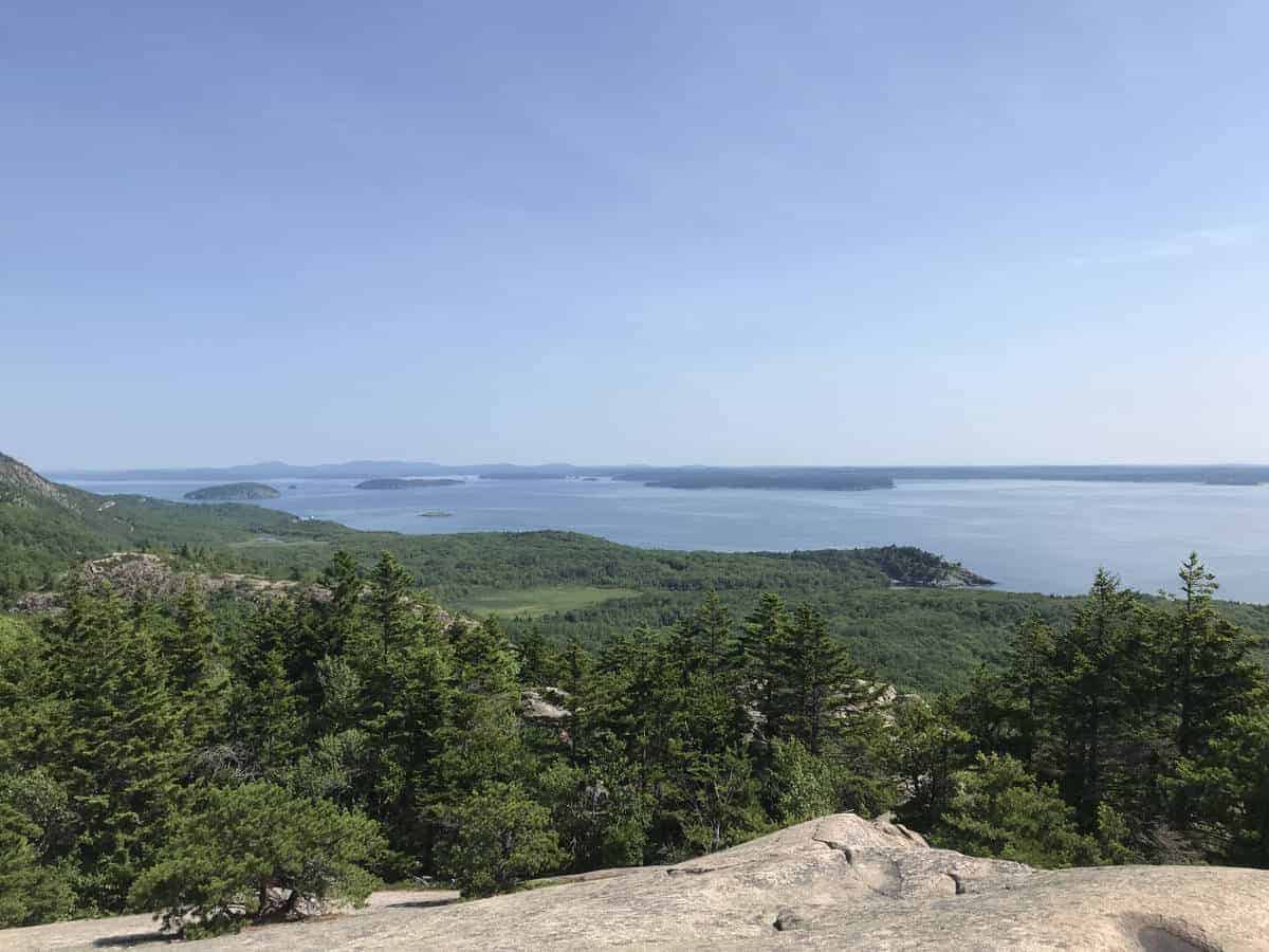
MAINE: Beehive Hiking Trail, Acadia National Park
The Beehive Trail at Acadia National Park, in Maine is a lot of fun to hike! It offers similar views to other trails in the area but is far less exposed. It is also open far more often during the year. Some of the other nearby trails are closed during the summer months to protect the peregrine falcons that nest in this area.
This trail is short, but strenuous. It basically requires a climb up the side of the mountain. The majority of the trail is dirt,but some portions require hikers to scramble up iron rung ladders or free-climb over large rocks. No technical skills or gear is required though it could be slippery and dangerous in wet conditions.
Because it is popular and quite crowded, the trail can only be completed in one direction. Don’t be put off by the fact that this trail requires hiking on a cliff edge. The views it offers of the Atlantic Ocean, and the bays and islands that lie within it are absolutely worth the challenge!
Another benefit to hiking this trail in the summer is that you can cool off in a large pond found nearby called the Bowl.
If you enjoy a challenge, you definitely want to put the Beehive Trail on your “must-stop” list for a New England road trip. Article and photo: Tranquil Trekker
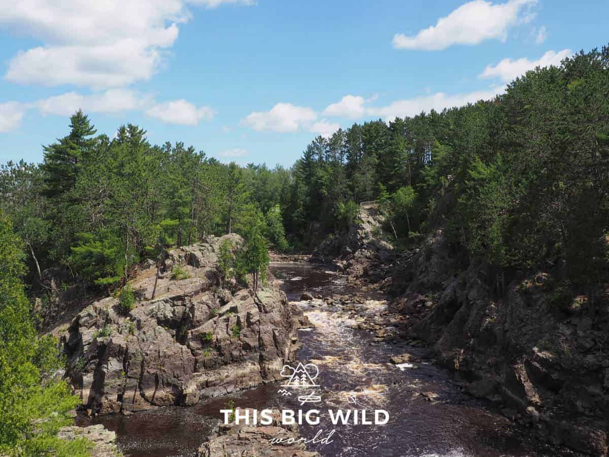
MINNESOTA: Superior Hiking Trail
The Superior Hiking Trail spans 306 miles along Lake Superior in northern Minnesota, from Canada to Wisconsin. The trail is lined with beautiful waterfalls, granite cliffs, stream crossings and incredible views of Lake Superior from its shoreline and above.
What makes the Superior Hiking Trail great for summer hiking is that there’s easy access to water and plenty of shade. The trail is broken into sections that vary in length from under two miles to more than ten miles. Hikers can string together as many sections as they’d like to customize an itinerary that works best for them!
Overnight parking is easily available at most trailheads and there is a shuttle service that can transport you back to your car when you’re done hiking. Did I mention that there are NO permit requirements for hiking the trail? That means you can easily plan a last minute trip.
The trail is managed by the Superior HIking Trail Association. They have a wealth of knowledge and resources on their website to help you plan your trip. Purchase their ‘Guide to the Superior Hiking Trail’ for a detailed breakdown of each section.
Add Minnesota to your bucket list and see why it’s an awesome summer destination for hiking and outdoor adventure! Article and photo: This Big Wild World
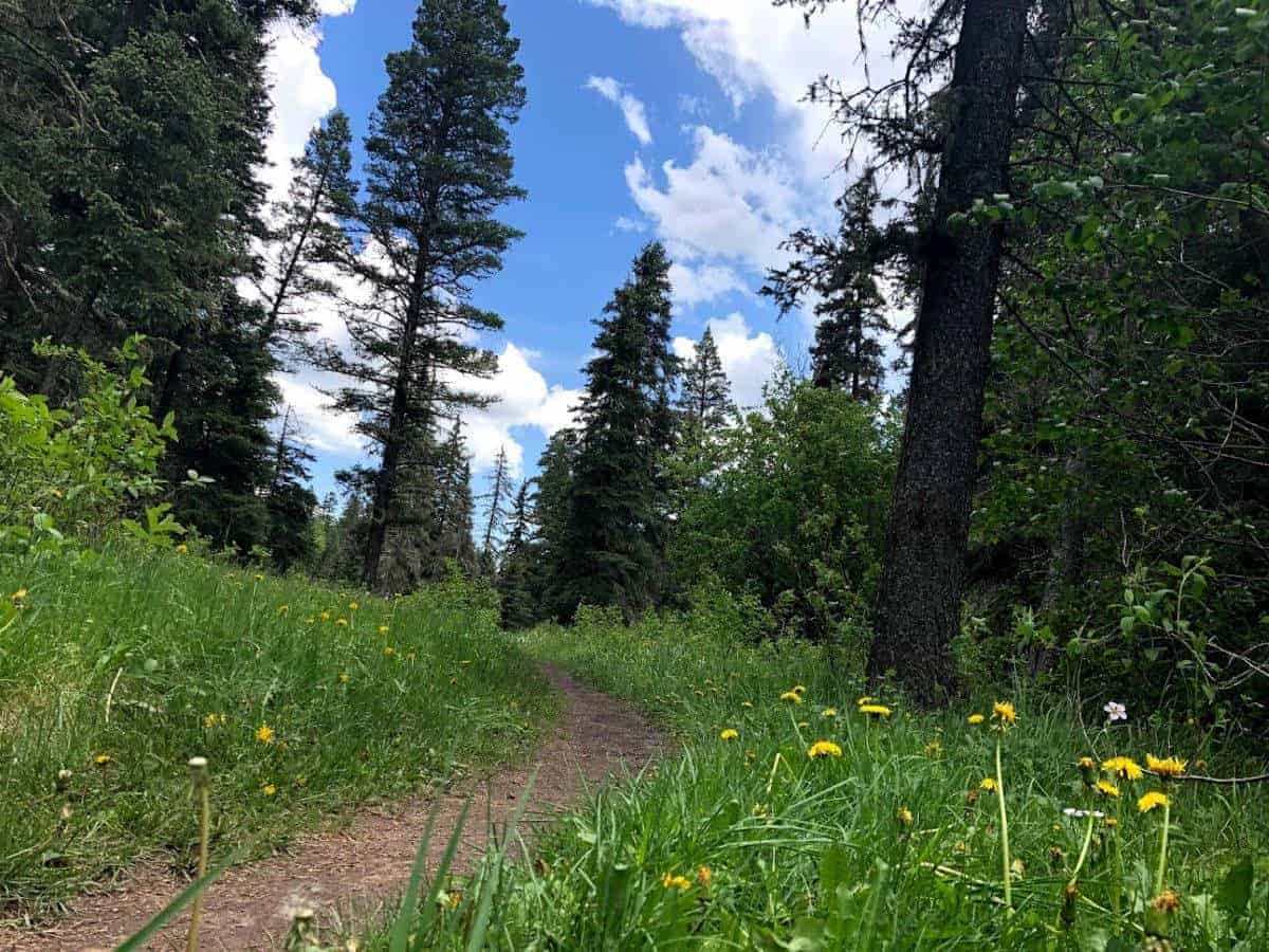
NEW MEXICO: Cave Creek Trail
When visiting Santa Fe or Albuquerque in New Mexico, you must hike the Cave Creek Trail in Pecos, about 1-2 hour away from these cities.
Starting from Panchuela Campground on the 8,400 ft. elevation, you will hike through Douglas-fir and Aspen trees, with wildflowers coloring the trail and blue sky canopied from above. In a distance, you will hear water flowing merrily in the creek. When you get to the water, you still have to cross a fallen pine bridge to reach the cave at the end of the trail.
Cave Creek Trail is a 5.6 mile lightly trafficked out and back trail, rated as moderate, and is best used from May until November. You will gain a little over 1,000 ft. in elevation, but even Texan like us could handle it. Dogs are welcome, but must be kept on leash. Back in the car, we all agreed it’s a beautiful hike. Even our dog Snoopy had a great time in the Pecos Wilderness.
Definitely one of the best hiking trails for summertime in the U.S. Just make sure to hike before afternoon to avoid summer storms that are common in the higher ground. Article and photo: Two Worlds Treasures
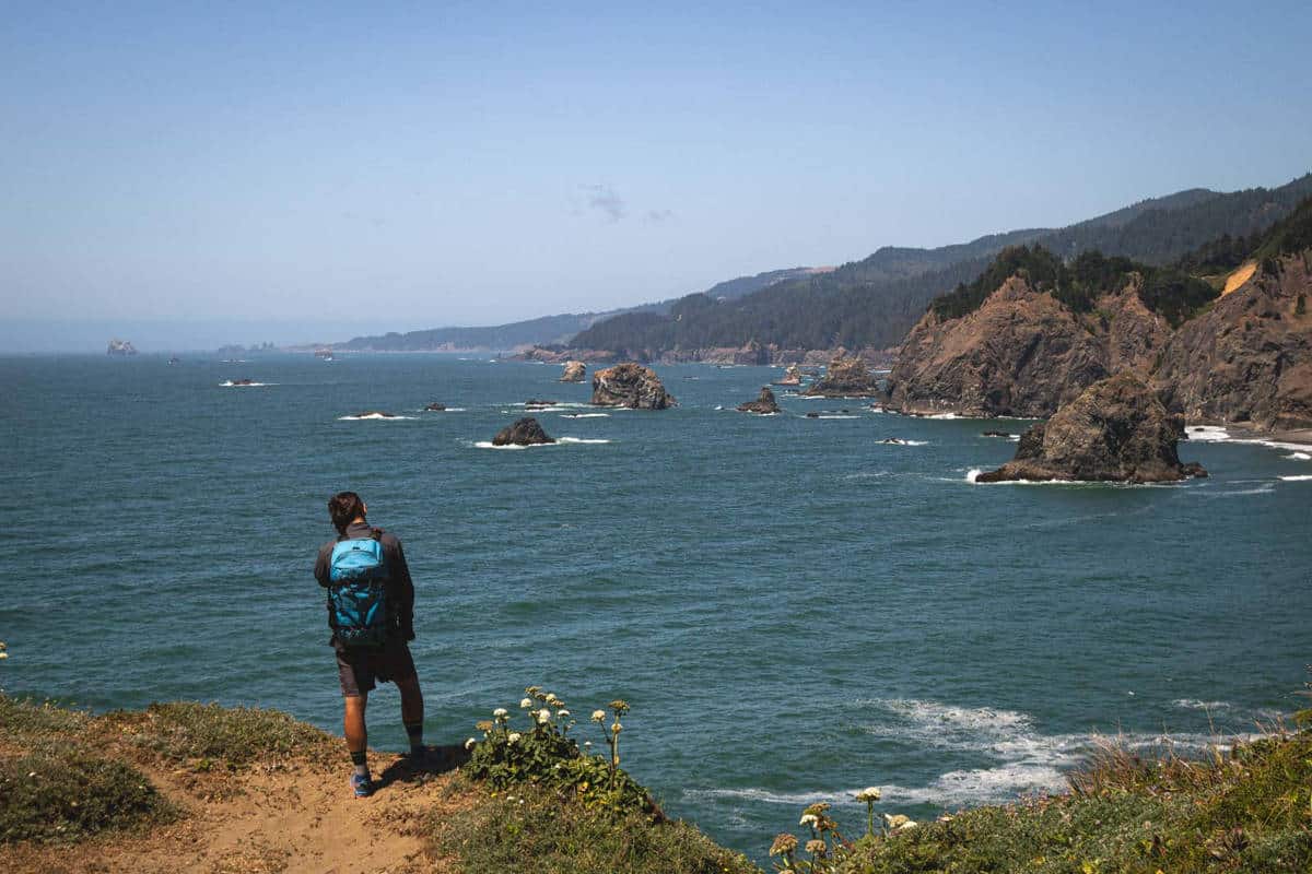
OREGON: Samuel H. Boardman Hiking Trails
There are some truly gorgeous Oregon coast hikes to check out. But the hiking trails at Samuel H. Boardman State Park are my favorite. There are actually numerous hikes to do this area and the best part is, they are all pretty short but very rewarding and you can see the area in one big day!
One of the most famous Oregon photography locations is Natural Bridges. You can get a great view just a few feet from the parking lot but taking a closer look is definitely worth it. It’s a bit dangerous, so take care, you’ll need to almost slide down a steep area to get to them and come pretty close to a cliff. But the views are iconic—gorgeous rocks carved out by the sea and dotting the coastline.
Lone Ranch South is just at the bottom tip of the Scenic Corridor and is probably one of the lesser-visited areas. Walk along the beach and up the hilly sand dunes for great views of the coast and some sea stacks.
Lastly, Indian Sands is a great loop with some sand dunes and vistas over the rough cliffside getting beaten by the waves.
Most of the Samuel H. Boardman hikes are between 1-3 miles and they all have a trailhead with a parking lot. Article and photo: Oregon is for Adventure
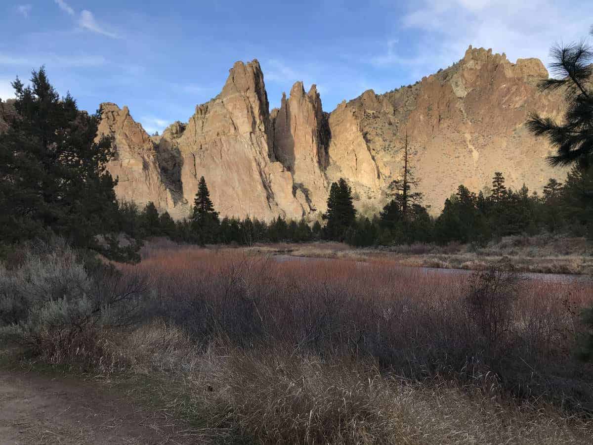
OREGON: Hiking Trails at Smith Rock State Park
As one of Oregon’s 7 Wonders, Smith Rock State Park deserves a visit for anyone traveling Central Oregon in search of hikes with incredible scenery. The park is located in Terrebonne, Oregon, however, you won’t find much in this small rural town.
Your best option for a basecamp will be in Bend, which is one of Oregon’s adventure hubs. You’ll find plenty of outdoor activities near Bend from hiking, biking, to stand up paddleboarding.
Smith Rock State Park offers 650 acres of protected land to explore by foot, bike or horse. The park is world-famous for its rock climbing, but blazing the trails lets you view the park in all of its marvels —from high to low. It’s a terrific place to visit in Oregon in summer to hit the trails, although during the hottest months it’s most comfortable to start early morning to avoid the heat of the day.
The park has an extensive trail network that offers routes for all abilities. If you don’t mind an uphill climb and want some of the best views of the Deschutes River and rock pillars, the Misery Ridge trail is a must. You’ll also get a great view of Monkey Face rock on the way down the ridge.
Another great option is hiking along the River Trail which meanders next to the Deschutes River at the base of towering rock spires. Whatever route you choose, you’re sure to marvel in the stunning landscapes of Smith Rocks. Article and photo: Bend Explored
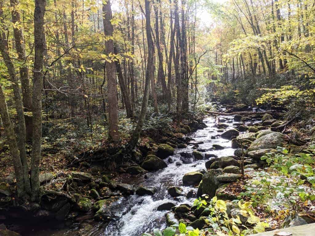
TENNESSEE: Laurel Falls Hiking Trail, Great Smoky Mountains National Park
The Great Smoky Mountains National Park is wonderful for hiking in the summer. The mountain air is cool enough to enjoy the hikes and the old-growth forests provide shade along the trail.
One of our favorite summer hikes in the Smokies is the Laurel Falls Trail. The trailhead is located along the Little River Road and can be easily accessed by entering the park near the Sugarland Visitor Center.
Laurel Falls is one of the most popular hikes in the Smokies, but you need to go early to find parking near the trailhead. This hike is 2.6 miles long round trip and of easy-moderate difficulty level. Along the trail, you can see the beautiful Smokies scenery and there is even a chance to spot black bears. At the end of the trail, you will find the stunning 80 foot Laurel Falls waterfall. The trail is paved and can be done by older kids. For younger kids, carry along hiking carriers.
This hike is beautiful in summer as the lush green plant life blooms along the trail and the waterfall itself flows with abundant water. There are a lot of photo opportunities along the hike and at the waterfall. You should plan at least 2 to 3 hours to enjoy this hike at a leisurely pace. We highly recommend Smoky Mountains in the fall to see the colorful foliage here! Article and photo: Dotted Globe
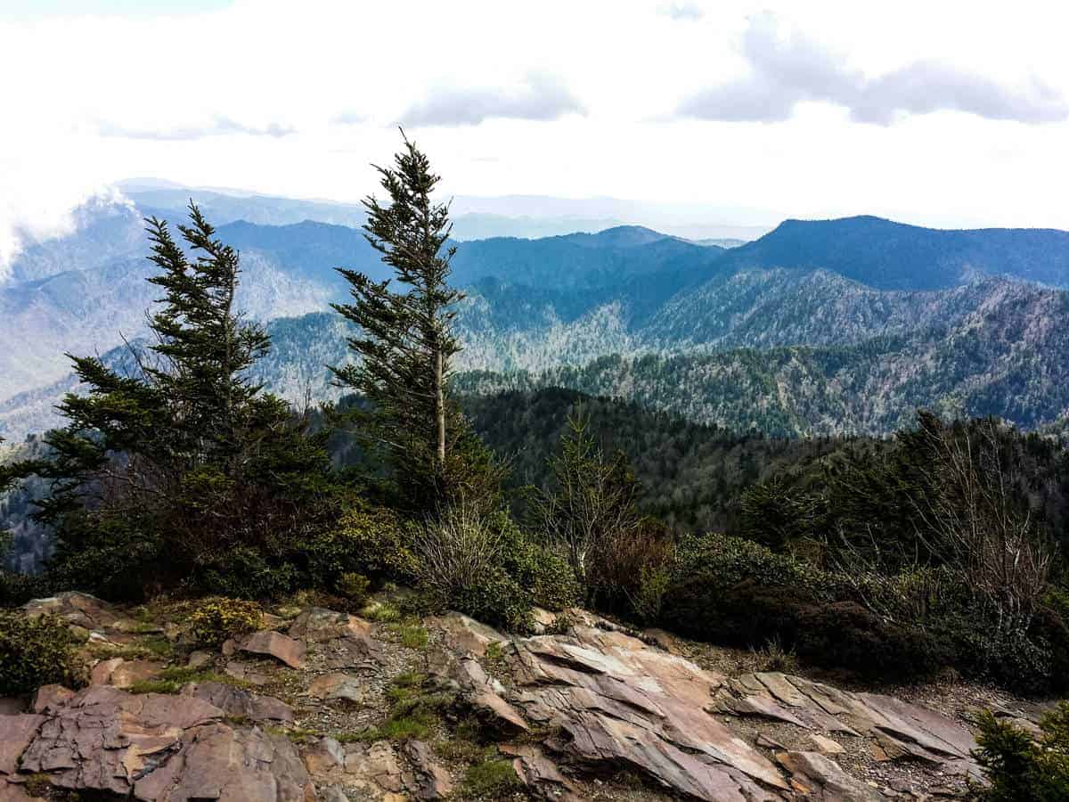
TENNESSEE: Mt. LeConte Hiking Trail, Great Smoky Mountains National Park
For seasoned hikers, Mt. LeConte is a gorgeous hike located within the Smoky Mountains. At 6,593 feet, it is one of the highest peaks in the Eastern United States. With 5 trailheads located throughout the Gatlinburg area, Mt. LeConte is one of the most heavily trekked mountains within Great Smoky Mountains National Park.
My personal favorite is the Alum Cave Trail, which passes by water, bluffs, caves, and the beautiful Arch Rock. At 4.9 miles each way, it is the shortest yet arguably the most strenuous path to the top. The other trails are less popular and offer more solitude, such as the Rainbow Falls, Boulevard, Bullhead, and Trillium Gap trails.
When you reach the top, you will find lodging, outhouses, a little shop to buy a snack or souvenirs, and some chairs so you can relax and enjoy the view. But don’t stop here! If you keep going, you will soon reach Myrtle Point. Myrtle Point offers panoramic views of the Smoky Mountains that make the hike worth it! Although this mountain is in the South, it is cold enough to snow from October to April. It also tends to be foggy when you get that high in the sky, so a clear summer day is the best bet for astounding views! Article and photo: Meals and Mile Markers
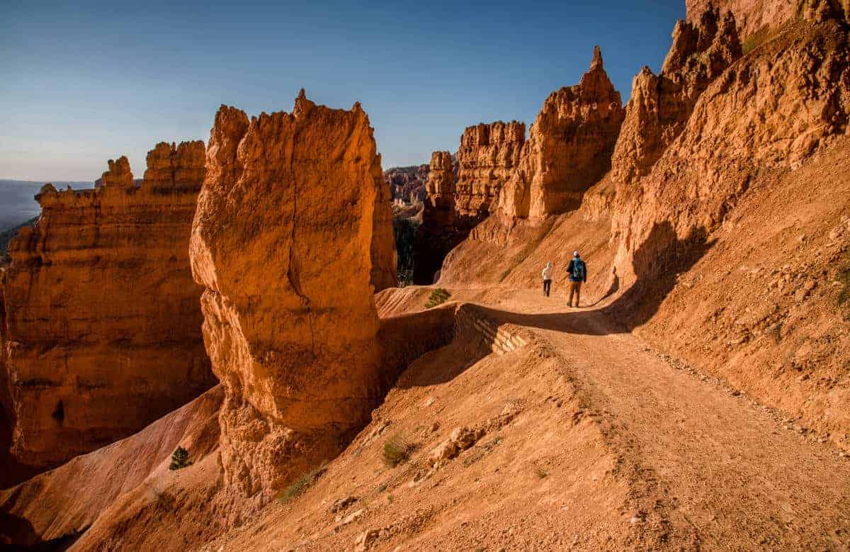
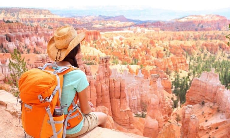
UTAH: Navajo Loop – Queen’s Garden Trail, Bryce Canyon National Park
The best way to experience Bryce Canyon National Park is to hike below the rim of the amphitheater and down into the canyon. The most popular way to enjoy the hoodoos up close is hiking the Navajo Loop – Queen’s Garden Trail.
The trail is easy to access from either Sunrise or Sunset Point, and you’ll walk by popular formations like Thor’s Hammer, Three Gossips, Wall Street, Queen Victoria and more.
But it’s important to remember when exploring any Bryce Canyon National Park summer hike that while going down may not be strenuous, the steep climb out is tough. Don’t underestimate this trail due to the short mileage compared to the other trails at Bryce Canyon.
If you don’t feel like doing the entire loop hike, we recommend you at least walk down the hiking trail near Sunset Point to see Thor’s Hammer a bit more closely. It’s worth that extra bit of effort to get an idea of what Bryce Canyon has to offer below the rim!
When hiking the Navajo Loop – Queen’s Garden trail in the summer, it’s best to do it in the morning. You can watch the amazing sunrise from Sunrise Point then start hiking while the temperatures are cool. Along the canyon floor you can take time to enjoy a snack under the shade of the trees. Hitting the trail early helps with the hike back up because you’ll be expending energy with the steep grade, there is not much shade, and the heat is amplified by the surrounding rock.
VIGINIA: Old Rag Hiking Trail, Shenandoah National Park
Virginia’s Shenandoah National Park is home to over 500 miles of hiking trails, but one hike in particular stands above all the others: Old Rag.
Though Old Rag is nowhere near the highest peak in the park, the hike to the top is uniquely rewarding. Old Rag’s ridgeline is composed of exposed rocks and tallis slopes, a landscape more like mountain tops out than in Virginia. And in order to reach the summit, hikers must traverse this ridgeline by squeezing between boulders and scrambling up rock faces. It’s one of Shenandoah’s most challenging hikes, but it’s also the most fun.
While Old Rag is a great Shenandoah hike to do year-round (as long as the rocks aren’t wet or icy), summer is particularly great. Summer flowers are in full bloom, the creeks at the base of Old Rag are refreshing, and Virginia’s greenery is on display. Just be sure to start the hike early in the day to beat the crowds and summer heat! Article and photo: Pink Caddy Travelogue
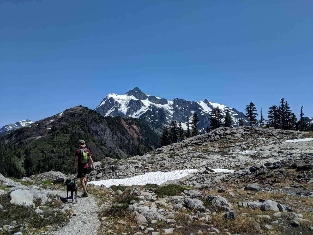
WASHINGTON: Chain Lakes Loop Hiking Trail
Chain Lakes Loop Trail is one of the most breathtaking trails I’ve done in the US. Breathtaking in every sense of the word. With 1,820 feet of elevation gain, it’s not for the faint-of-heart, but for all that climbing, you will be rewarded with beautiful views of the glaciated volcano of Mt. Baker along with other mountains in the area.
Traveling east from Bellingham WA. you’ll take the 1h30 journey up the dead-end road towards Mt. Baker where you’ll find Austin Pass Visitors Centre.
You can make take the Chain Lakes Loop Trail in either direction as you’ll be climbing for the first mile either way. Clockwise has steps, and anti-clockwise has switchbacks, you decide which you’d prefer to climb or go down. The trail is relatively rough with some loose rock, along with the occasional small snow patch during the early summer. Because of this, I’d advise sturdy footwear and even poles if you’re not 100% confident on your feet.
Due to the higher elevation and snowpack, the trail is only open in summer and fall. The weather is also very unpredictable in the mountains, so be sure to check out the National Forest Service Website for announcements.
Here’s a list of even more hiking trails around Bellingham, Washington. Article and photo: Illness to Ultra
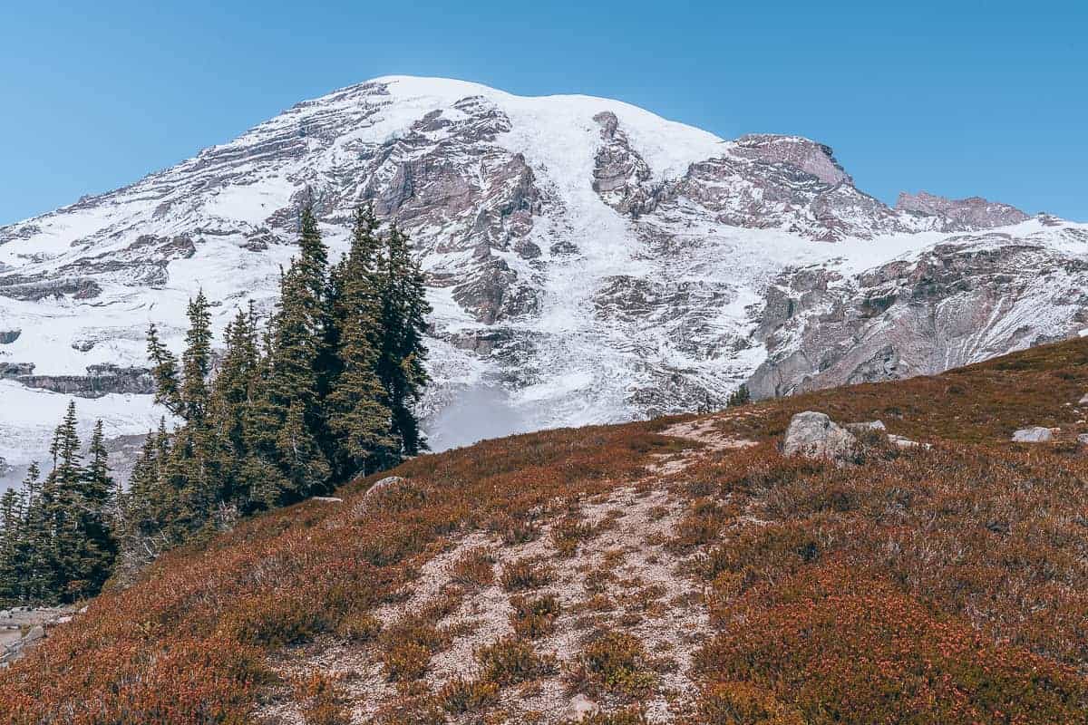
WASHINGTON: Skyline Hiking Trail, Mount Rainier National Park
One of the best hikes to do this summer is the Skyline Trail, located in Mount Rainier National Park, Washington. This trail is the most popular Mt. Rainier hike because you get outstanding views of Mount Rainier throughout the whole trail!
This hike will take you a while to complete because you won’t stop taking pictures every 5 minutes! Getting on a path that highlights Mount Rainier’s vast beauty and immensity is one of the best things you can do this summer.
The hike is a loop trail of 5.5 miles, roundtrip, and an elevation gain of 1450 ft. Families flock to this trail in the summertime. Since there are views throughout the hike, it is effortless to call it a day and turn around if it gets too difficult. Almost every turn has beautiful views.
Also, there is a great surprise in one section of the loop. A fantastic waterfall called Myrtle Falls. If you are looking for one of the best trails to do in Washington or even in the USA in the summer, this is it! Skyline trail is one of the best hikes I have ever experienced before. Article and photo: The Wandering Queen
WISCONSIN: Ice Age Trail
Wisconsin may be an off-the -beaten track destination for many travellers, however it is one of the most beautiful places to visit if you are a nature and outdoor lover.
If Wisconsin is a paradise for nature kids, then the Ice Age Trail with the scenic Devil’s Lake is the holy grail! Frequently listed as one of the best weekend trips in Wisconsin, the surroundings and the lake itself is famous for its enchanting rock formations and spectacular viewpoints.
The famous Ice Age Trail passes along the Devil’s Lake and is thus one of the top things to do here. However there are many more outdoor activities that can be done near Devil’s Lake: climbing, swimming, biking and running. However, the trail goes to many more parts of Wisconsin, thus you hike parts of it in Southern, Central and Northern Wisconsin.
The best time to do this emblematic trail visit is in summer when the lush woods are shining in lush green. Article and photo: Paulina on the Road
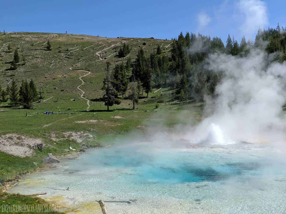
WYOMING: The Fairy Falls/Imperial Geyser Trail
The Fairy Falls/Imperial Geyser trail in Yellowstone National Park takes you by beautiful geological formations, a stunning waterfall, through quiet woods, and alongside colorful wildflowers for an easy day hike.
The trail starts off near one of the national park’s most popular attractions, the Grand Prismatic Spring, but ends by a geyser you’ll only have to share with a few people. Mileage estimates vary depending on the source but somewhere between 8 & 9 miles, however it’s extremely flat and accessible for most hikers.
This is a fantastic hike to take in summer because the sun & heat burns off more of the steam over the geysers, making them much more vibrant (this is the rare hike I suggest you start near lunch instead of in the early morning)!
In early summer you might still find snow near Fairy Falls and wildlife is active in the area (don’t forget bear spray!). We hiked this trail with my 4 and 6 year old without any trouble; find more Yellowstone hikes for families! Article and photo: Explore More Clean Less
CLICK TO SHOP FOR US NATIONAL PARK GUIDES & MAPS


Wow, so many beautiful trails, I would love to visit Washington some day, your photos are stunning. Thank you for sharing.
Awesome and so many wonderful trails to explore.
Thank you for sharing your links with us at #271 SSPS Linky. See you again next week.
You guys need to come to Wild, Wonderful West Virginia and visit our nation’s newest National Park, New River Gorge. If you do, check out Endless Wall Trail, and Bridge Walk ($$) is exhilarating.
We DO need to visit that new National Park. Thanks for the recommendation for this trail, sounds amazing!
Thank you for sharing – and including the Great Smoky Mountain trails. Those are in my back yard and are beautiful. #HomeMattersParty
You are lucky to have the Smoky Mountains in your back yard!
What a wonderful post! SO much useful information, and such gorgeous photos to go with it. I’ve pinned your post for future reference. National Parks are a wonderful resource, aren’t they?
Thanks so much for joining the Grace at Home party at Imparting Grace. I’m featuring you this week!
Thank you for the feature! Yes, we love exploring National Parks!
Thank you for sharing all this information on these awesome hikes. I have pinned so that I can come back to this post in the very near future!
Thank you for the pin… summer hiking is so fun!