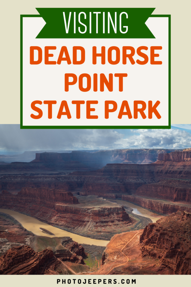
Dead Horse Point State Park Travel Guide
Dead Horse Point is a must-stop destination on our list of Utah State Parks if you’ll be in the Moab area. Use this Dead Horse Point State Park travel guide to plan your time at this unique location: what to pack, where to stay, things to do and more!
Tucked away in the scenic state of Utah, this park boasts a breathtaking landscape that’s truly a marvel to behold. Whether you’re an ardent hiker, a photography enthusiast, or just someone who appreciates nature’s raw beauty, Dead Horse Point State Park is a destination you’ll not want to miss.
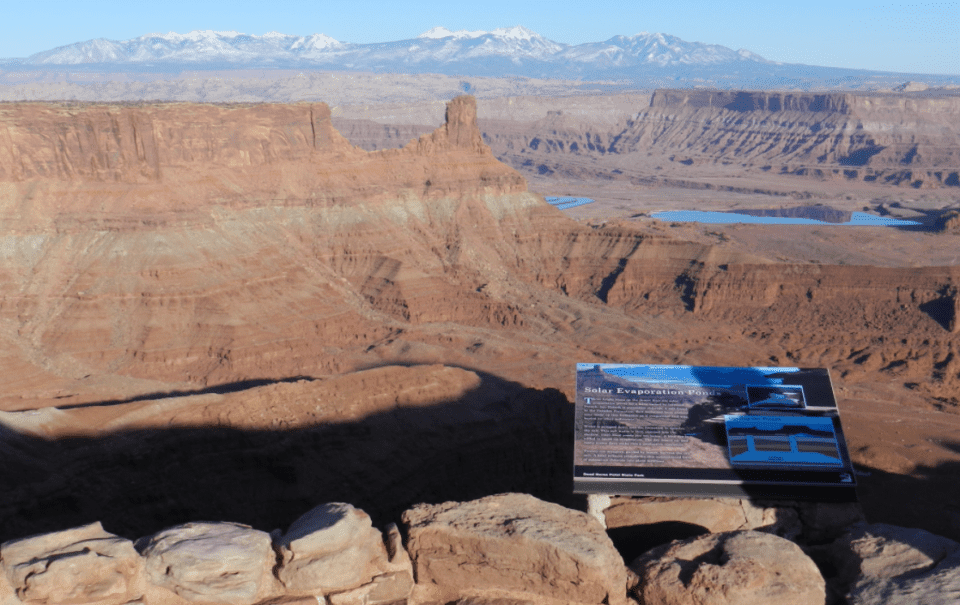
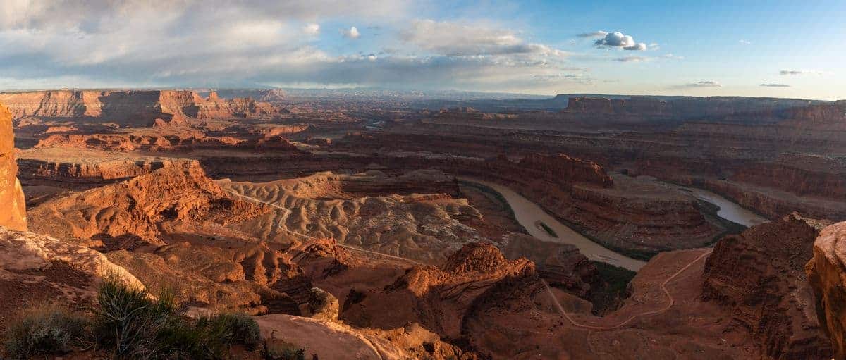
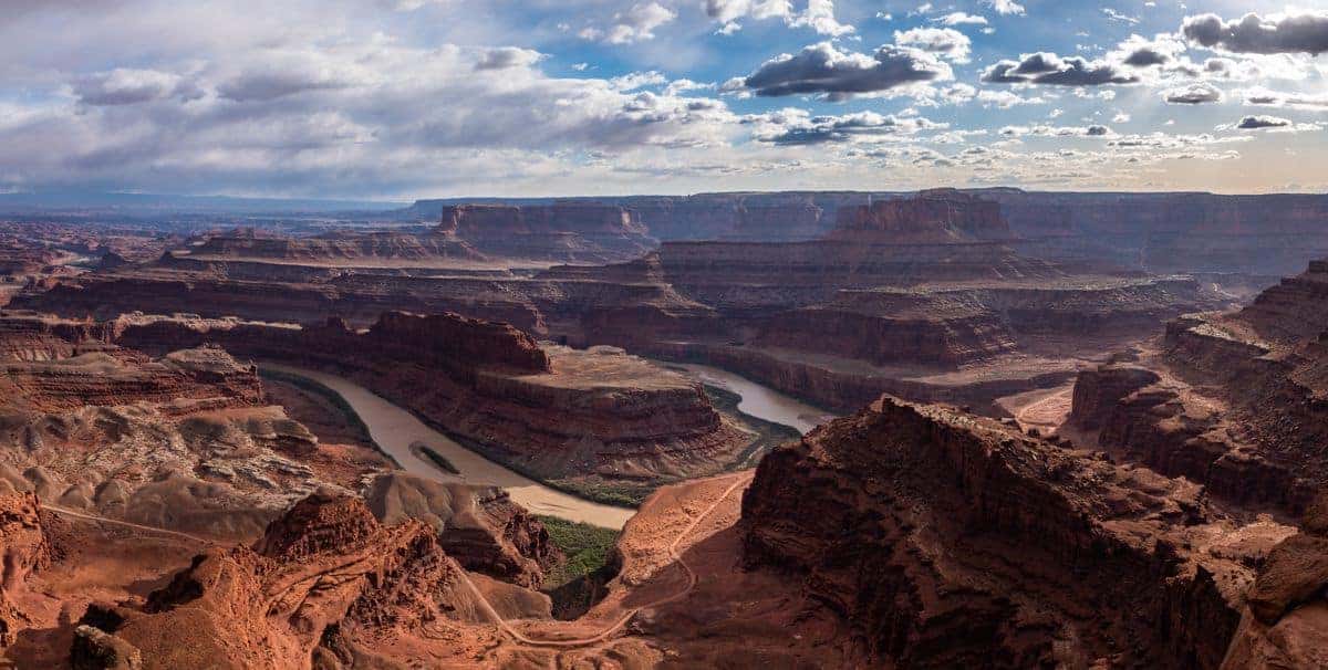
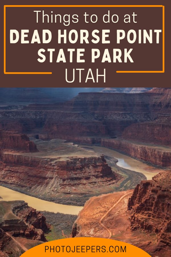
The park is located near the Canyonlands National Park Island in the Sky entrance. Dead Horse Point is known for its stunning views of the Colorado River, dramatic vertical cliffs, canyons, and vista views.
We live just hours away so we’ve been able to visit the state park during every season and all types of weather. This guide is based on our experiences over the years.
There are two tips we want to share right off the bat! First, pack your camera gear so you can capture Dead Horse Point State Park photos of the stunning views you’ll see here!
Second, be prepared for the weather and temperatures you’ll experience based on the time of year you visit. Use our Utah Packing Lists to make sure you have the right clothing and gear for visiting any season! Grab your free printable packing checklist by clicking the image below!

This site contains affiliate links which means WE may receive commissions for purchases made through these links. We only provide links to products we actually use and/or wholeheartedly recommend! As an Amazon Associate, we earn from qualifying purchases. Read the full Disclosure Policy.
Dead Horse Point State Park Travel Guide
Definitely add this stunning state park to your list of places to visit in Utah.
Located near the adventure town of Moab, Dead Horse Point is known for its ever-changing landscape and exquisite views of the Colorado River. It’s filled with dramatic vertical cliffs, austere canyons, and stunning vista views.
If you’re planning to visit Canyonlands Island in the Sky, this is a must-see side trip!
When to Visit Dead Horse Point
While there isn’t a bad time to visit Dead Horse Point State Park, some seasons are better for exploring this Utah state park than others.
If you plan to do hiking or biking, the best time to go to Dead Horse Point State Park is spring or fall, when weather conditions are ideal. In contrast, temperatures throughout the summer can get quite high which aren’t ideal for doing Dead Horse Point State Park hikes.
On the opposite end of the spectrum is winter, where temperatures routinely dip below freezing, making snow likely, and a difficult obstacle to overcome when exploring the area.
Dead Horse Point Operating Hours
Dead Horse Point State Park is open year round, between 6:00 am and 10:00 pm.
Fees for Visiting Dead Horse Point
If you’re planning to visit Dead Horse Point State Park for the day, please be aware that all day-use park entries are valid for three consecutive days. Check the Dead Horse Point website for current fees. If you are a Utah resident, we recommend purchasing the Utah State Parks pass BEFORE YOU GO.
The US National Park pass is not valid here since this is a Utah State Park.
But we feel the additional fee to visit this park is well worth it to view this iconic scene you can’t see at Canyonlands.
Weather at Dead Horse Point State Park
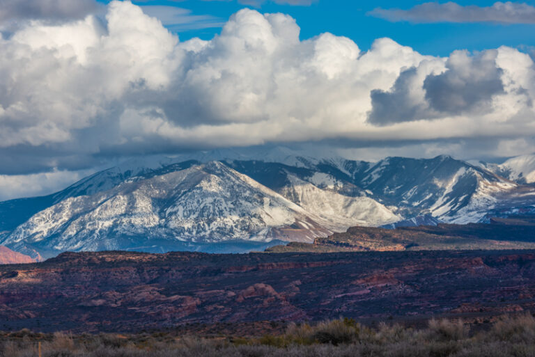
Because the Southeastern portion of Utah is part of the Colorado Plateau, this region is regarded to be a “high desert” climate. The Moab area weather, including Dead Horse Point State Park, regularly experiences huge temperature fluctuations, of up to 40 degrees, in a single day.
That’s why the most temperate, and best time to visit the park, is during the spring (between April and May) and the fall (between mid-September and October). Throughout these seasons, daytime highs usually average between 60º and 80ºF (15º and 26ºC) while nighttime lows usually average between 30º and 50ºF (-1º to 10ºC) .
In contrast, summer temperatures regularly exceed 100ºF (37ºC), making strenuous activities difficult. Late summer monsoons also bring violent storms to the areas can cause dangerous flash floods.
Winter weather in the park is similarly extreme, with highs between 30º and 50ºF (-1º to 10ºC) and lows between 0º and 20ºF (-17º to -6ºC). Although heavy snowfall is rare, even trace amounts of snow and ice can make local trails and roads virtually impassable. Wear winter clothing to stay warm while exploring the park!
Dead Horse Point Pet Policy
Like many other Utah state parks, Dead Horse Point is dog friendly and welcomes pets on all of the area’s hiking trails and in the campground. That being said, to protect both your pets and the area’s indigenous wildlife, pets must be leashed at all times and are not allowed on any of the Intrepid Mountain Biking trails.
Pets are also not permitted in yurts and must never be left in vehicles, where temperatures can routinely exceed 140ºF on a semi-warm day. Owners are also required to clean up after their pets, and can easily do so using the park’s many dog waste bag dispensers.
Goods and Services at Dead Horse Point State Park
Gift Shop – Located inside the visitor center, and this store offers visitors a variety of quality souvenirs including shirts, hats, postcards, mugs, magnets, art work, pottery, snacks, and more! Both the gift shop and visitor center are open daily between 9:00 am and 5:00 pm.
Pony Expresso Coffee Shop – Open between March and October (right in time for the park’s busy season), this charming little coffee shop is located just outside of the Dead Horse Point State Park Visitor Center and offers guests an assortment of warm beverages as well as various food items that you can take with you on any, Dead Horse Point State Park hike.
Camping – See below.
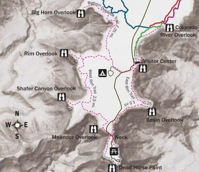
Dead Horse Point State Park Map
Check out the simple map for you to navigate your way around Dead Horse Point:
- Visitor Center: Your first pit-stop, where you can gather all the essential information about the park.
- Kayenta Campground: Ideal for overnight campers, this area is equipped with modern facilities.
- East Rim Overlook: One of the park’s most scenic spots, offering panoramic views of the canyon.
- West Rim Overlook: Another viewpoint offering a different yet equally stunning perspective of the landscape.
- Hiking Trails: Various trails, including the easy-going Rim Walk and more challenging Big Horn Overlook Trail.
Remember, this is a simplified representation. Always keep an official map handy and stay on the marked trails for safety.
You can also see the online Dead Horse Point interactive map.
How to Get to Dead Horse Point State Park
From Grand Junction, Colorado, take I-70 west and follow the highway until Thompson Springs. Take exit 182 and follow US-191 south towards Moab. Continue along US-191 until you reach UT-313 and turn right. It should take about 2 hours to travel 124 miles.
From Salt Lake City, Utah, take I-15 south until exit 257 B-A for US-6 East. Continue on US-6 East and merge onto I-70 East. Take exit 182 onto US-191 south towards Moab. Continue along US-191 until you reach UT-313 and turn right. It should take 4 hours to drive 245 miles.
Things to Do at Dead Horse Point State Park
There are a variety of activities to enjoy: hiking, biking, camping, and landscape photography.
Hiking Trails at Dead Horse Point
Avid hikers will enjoy navigating the seven miles of trails that wind through the exquisite, desert plateau landscape of Dead Horse Point State Park. Connecting to eight scenic overlooks throughout the park, these Dead Horse Point State Park hiking trails are fairly easy and have minimal elevation change. However. Because of uneven slick rock along many of the trails, guests are advised to wear sturdy footwear.
Listed below are some of the best Dead Horse Point State Park hikes, which include:
Overlook Trail – This easy, 200 foot trail is one of the top attractions in Dead Horse Point State Park. From the overlook parking lot, you’ll find a short paved pathway that culminates in breathtaking views of the Colorado River. From this outlook, paved pathways lead to additional viewpoints along the East and West Rim trail systems (these trails have steep inclines and sections of slick rock).
Visitor Center Trail – This easy, ⅛ of a mile trail is a paved pathway that is accessible from the visitor center. In addition to providing hikers with great views of the basin to the east, the La Sal Mountains, and Chimney Rock, this trail also has eight, unique, trail-side exhibits that highlight some of the common desert plants and trees that you’ll see during your visit to the park..
Colorado River Overlook – This easy, 1 mile hike winds north from the visitor center and takes hikers along the east rim, eventually ending with a fabulous view of the Colorado River. Along the route, hikers will notice a series of large, seasonal pools of water that make this trail an ideal place to spot wildlife.
East Rim Trail System – This easy, predominantly flat, 1.5 to 2 mile hike starts at the visitor center and brings visitors along the eastern side of the mesa top, eventually terminating at Dead Horse Point. Along the way, hikers will enjoy panoramic views of the La Sal Mountains, the Behind the Rocks area, sagebrush flats, and juniper forests.
West Rim Trail System – This moderately difficult, 2.5 to 3.5 mile hike is one of the longest hiking trails in the park. It starts at the visitor center, passes through the campground, and follows the cliffs along the western boundary of the park. This trail is more primitive, and not as well traveled, so be sure to follow cairn-marked routes over exposed sections of sandstone and slick rock.
Bighorn Overlook Trail – This moderately difficult, 1.5 mile trail is the longest spur off the West Rim Trail and relatively isolated from the remainder of the park. As a result, you may just have this trail all to yourself and can marvel at spectacular views that rival those found at Dead Horse Point itself. Like many West Rim trails, this route follows cairns across slick rock and has short sections of moderate cliff exposure. As a result, be sure to hike with caution and wear sturdy footwear.
Biking Trails at Dead Horse Point
Similarly, mountain bikers will enjoy Dead Horse Point State Park’s extensive, Intrepid Trail System. In total, this trail system covers 16.6-miles and includes only non-motorized, singletrack trails.
These various trails wind through vast juniper forests, over slickrock terrain, and offer riders stunning views of the canyons below. Additionally, the main trailhead can be accessed at the visitor center parking lot while the secondary trailhead can be accessed by turning towards the Moenkopi Yurts and then by taking the first road on your right, before you get to the yurts.
Some of Dead Horse Point State Park’s top biking trails include:
Intrepid Trail – This easy, ½ mile trail takes a mere four or five minutes to complete. It’s perfect for beginners since there is little elevation change over the trail’s rocky terrain.. At the end of the trail, you’ll also enjoy an excellent view from the Colorado River Overlook.
Great Pyramid Trail – This easy to moderate level trial is 2.2 miles long and takes between 20 and 25 minutes to complete. It takes riders along semi-rocky terrain of varied elevations and offers bikers a sweeping view of the Colorado River and the “Great Pyramid” formation in the distance.
Raven Roll Trail – This easy, fast-moving, semi-sandy, 1.7 mile trail takes between 8 and 12 minutes to complete. Along the way, riders will experience some changes in elevation and can continue on to either the Great Pyramid Trail or the more difficult, Big Chief Trail.
Big Chief Trail – This easy to moderate level, 3.6 mile trail takes between 32 and 38 minutes to complete and has plenty of slick rock and elevation changes that more advanced riders will enjoy. At its northernmost point, the trail culminates at the “Big Chief Overlook,” a perfect place to enjoy incredible, panoramic views of the surrounding canyons and La Sal Mountains.
Crossroads Trail – This 1.7 mile, easy to moderate level trail takes between 11 and 15 minutes to complete. As the name suggests, Crossroads connects with Big Chief and Raven Roll in the east and with Whiptail and Prickly Pair in the west. Filled with a series of short dips and rollers, this is a fun and fast paced trail that any biker will love. However, all riders are required to dismount from their bikes as they cross the park entrance road.
Whiptail – This 2.6 mile, moderate level trail takes between 22 and 26 minutes to complete. Riders along this smooth, fast paced trail will explore the park’s western most boundary, with drops in elevation as you move from north to south. Bikers will also love the views from the fantastic, 1000 foot overlook, into Shafer Canyon, along the way.
Twisted Tree – This 1.5 mile, moderate to difficult level, slick rock trail takes between 15 and 18 minutes to complete. It’s a fun, scenic ride that follows along the rim of Shafer Canyon.
Prickly Pair – This trail includes the 2.2 mile Prickly Trail and the 1.8 mile Pair Trail. Each of these trails should take 24 to 26 minutes and 16 to 18 minutes to complete respectively. Of the two trails, Prickly is more difficult, with a lot of slick rock and elevation changes that riders must traverse. In contrast, Pair Trail is the more moderate of the two and passes through areas of light sand and slickrock.
Geocaching at Dead Horse Point
For visitors who love Geocaching, (a game where people use handheld GPS units to locate hidden containers), Dead Horse Point has two official geocaches that are located either along trails or in day use areas. No rock scrambling or off trail hiking should be required to find either of these locations.
The official coordinates for the geocaches in the park are N 38 28.308, W 109 44.417 (Dead Horse Point main) and N 38 29.331 W 109 45.026 (Dead Horse Point west) respectively.
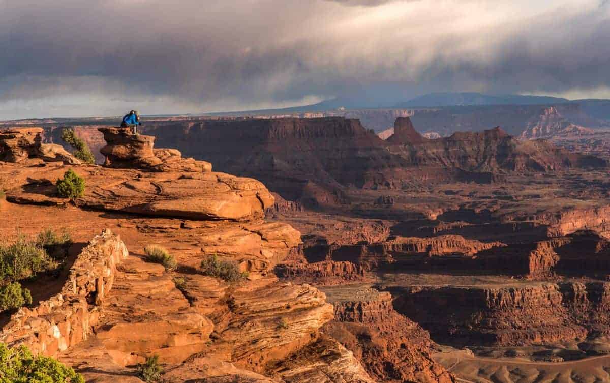
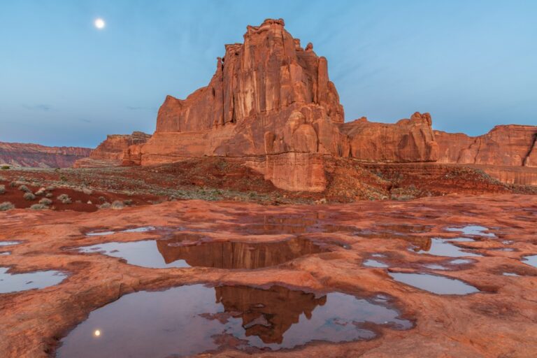
Photography at Dead Horse Point
One of the big draws to this location is for people to capture Dead Horse Point State Park photos!!
Drone Regulations at Dead Horse Point State National Park
Because this small state park experiences high rates of visitation, drones are banned, between March and October, out of respect for peoples’ privacy and enjoyment.
However, between November 1st and February 28th/29th of every year, drones may be used in the park, but only with proper permits. Permits can be obtained at the visitor center, or you can get a Dead Horse Point online drone permit online, where they must then be approved by park staff.
The use of drones at the main viewpoint of Dead Horse Point is always prohibited.
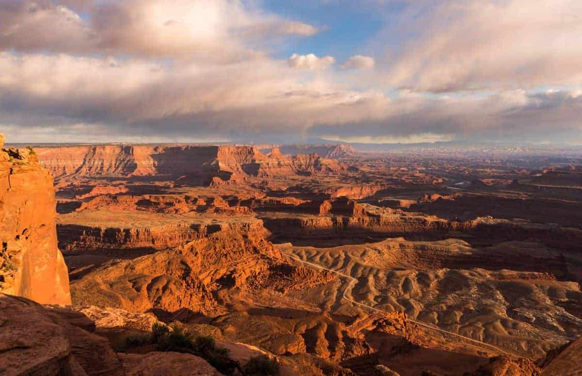
Dead Horse Point Sunset Photography
The best time to photograph Dead Horse Point is at sunset when the landscape gets that red glow. We have found it best to find a spot along the trail below and to the right of the platform to capture the Dead Horse Point sunset.
There may be quite a few people there to watch the sunset, but there is plenty of room along the canyon rim for everyone to have a great view!
PHOTO TIP: Be open to other Dead Horse Point photo opportunities like the red glow on the rocks, the people watching on the rocks, or using elements in the landscape to highlight the scene.
Night Sky at Dead Horse Point State Park
With the advent of electricity and it’s subsequent introduction into the modern world, the quiet, dark, and peaceful beauty of the night sky has all but disappeared from our lives.
To address this issue, Dead Horse Point State Park became an International Dark Sky Park in 2016 and a refuge for dark skies, filled with stars. As a result, Dead Horse Point State Park is now one of the best areas to go stargazing in all of Moab, especially since the park’s high plateau location and distant mountain ranges help shield the area from any urban sources of ambient light.
To facilitate the stargazing experience, park staff routinely lead programs that include everything from celebrating the night sky to walks under the full moon to gazing through telescopes at objects millions of light years away.
Where to Stay Near Dead Horse Point
There are no lodging facilities, only camping. You’ll find all types places to stay in Moab, just 30 minutes away.
Dead Horse Point State Park Camping
Camping at Dead Horse Point State Park can be a great way for guests to fully immerse themselves in the natural beauty of this amazing place. Some of the best Dead Horse Point camping spots include:
Wingate Campground – Perched atop a mesa with exquisite, panoramic views of the surrounding landscape, Wingate Campground has 31 campsites in total, 20 of which have electrical hookups, for RVs and tent campers, and 11 of which are hike-in, tent only sites.
Additionally, all sites at this campground have access to fire-pits, picnic tables under shelters, modern bathrooms with running water, and a communal dump station near the campground entrance. If a campsite is not reserved then they can be bought on a first come-first serve basis on the day of arrival.
Wingate Yurts – The Wingate Campground has four yurts for guests to enjoy. Each yurt can hold up to six people. As the park’s version of glamping, all yurts include heat, air conditioning, electricity, a bunk bed with a full mattress on top and a queen mattress on the bottom, a futon, indoor/outdoor tables, and a BBQ on the deck. However, please remember that cooking, flames of any kind, and pets are ALL not allowed in the yurts. Light cleaning is also required before checking out of the site.
Kayenta Campground – Nestled inside a charming little juniper grove is this peaceful little campground. It has 21 campsites to choose from, all of which include lighted shade structures, picnic tables, fire rings, and tent pads. Additionally, all sites are equipped with RV electrical hookups (20/30/50 AMP) and have full access to modern restroom facilities.
Moenkopi Yurts – Hidden along the Intrepid Trail System, these five, private yurts are the perfect place to go and escape the chaos of the city. Experience stunning sunrises amidst the area’s beautifully dynamic natural landscape, and all without forsaking any of the comforts of home. Not only can each yurt accommodate up to six people, but each one also includes a bunk bed , a pullout futon couch, an outdoor propane grill, heating, air conditioning, and electrical outlets. Modern restroom facilities are also located within walking distance, making this a fun and luxurious way to get back to nature.
We hope these travel tips help you to plan a visit to Dead Horse Point State Park. It’s definitely worth a stop!
Things to Do Near Dead Horse Point
- Moab Activities
- Moab Tours
- Arches National Park Activities
- Arches National Park Tours
- Canyonlands National Park Activities
- Canyonlands National Park Tours
Nice post. Your are a good travel resource!
Thank you!
We went there three years ago. Beautiful scenary. One of the locals we met at a rest area told us about it. Well worth the visit.
I’m glad a local told you to visit – it really is spectacular!
Truly enjoyed your pics and insight! I went there back in the 70’s so I can understand the beautiful vistas there ( most of my pics are on slides).
Thank you Steve. I bet when you visited in the 70’s it wasn’t very crowded compared to today!